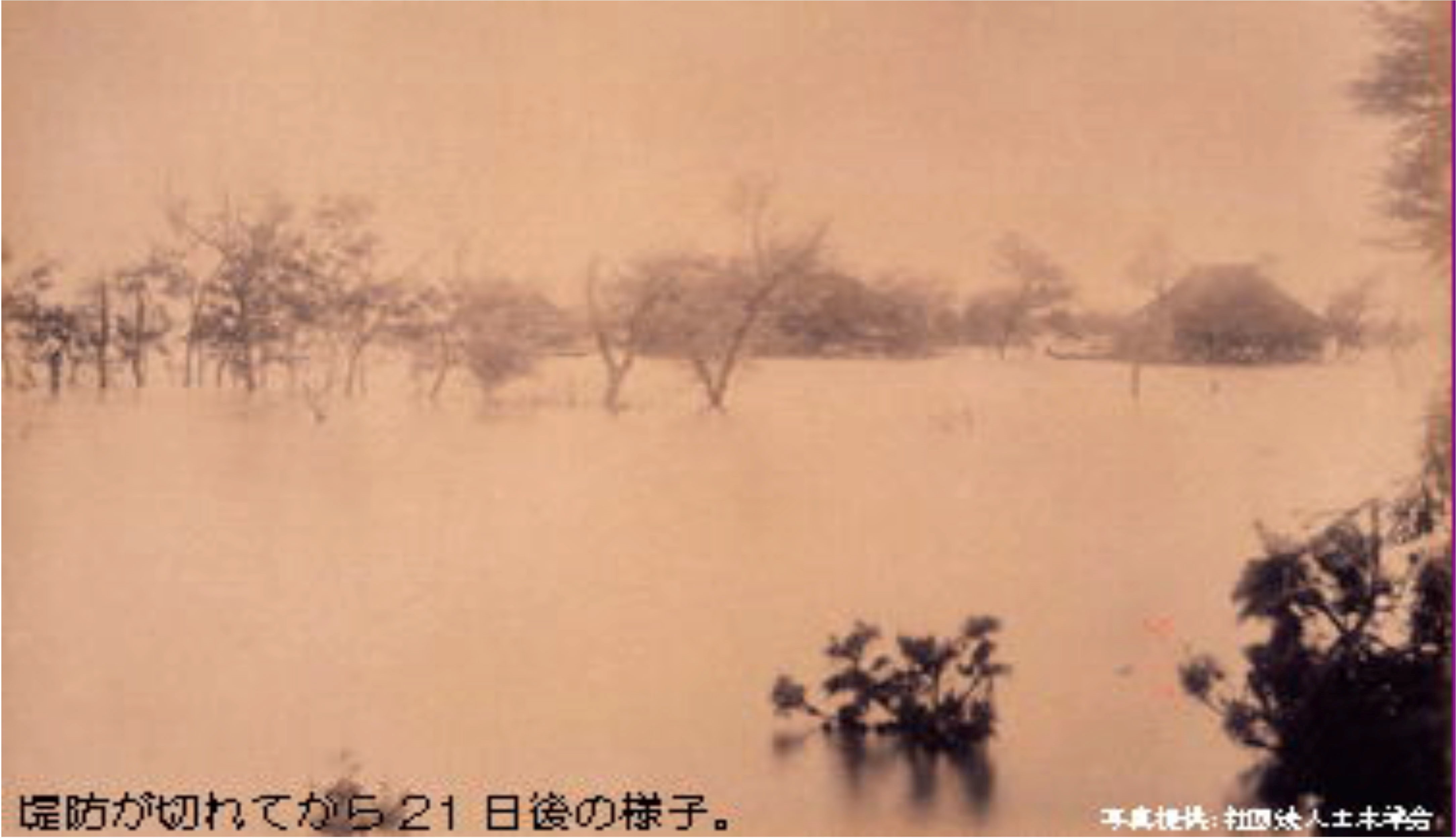
On 26 July 1896, after days of rain, the waters of the Shinano River broke through the dikes at Yokota village (southwest of Niigata City) on the Echigo Plain, causing massive flooding. Stagnant water soaked the land for weeks. That event sparked the construction of an overflow channel first proposed in the 1730s, the Okotsu Diversion Channel (Okotsu Bunsui). Today many residents regard it so highly that they have proposed nominating the entire Echigo Plain as a UN cultural heritage site.

Stagnant floodwaters 21 days after the 1896 flood
Stagnant floodwaters 21 days after the 1896 flood
Credit: Japan Society of Civil Engineers, Tokyo, Japan.
 This work is licensed under a Creative Commons Public Domain Mark 1.0 License.
Despite plaudits for Niigata’s reengineered waterways, their impact has redefined the nature of flood risk, rendering new areas “safe” for industrial and residential development. However, riparian engineering has actually created new risks of floods for new groups of stakeholders—residents and business located in areas that modern engineering and government officials have implicitly or explicitly redefined as “safe” or “stable.” These include residents of Niigata’s new suburban and downtown areas previously thought to be at high flood risk. The new uncertainties arose from engineering solutions developed in isolation from other hydrological forces and changing water usage patterns.

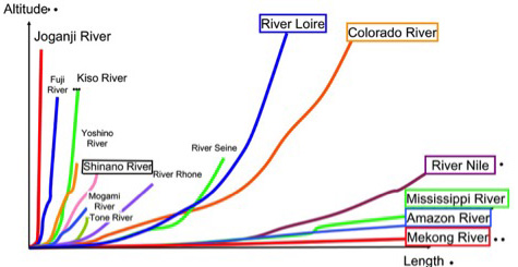
Comparison of Japanese and selected world river gradients
Comparison of Japanese and selected world river gradients
Image modified from an original prepared by the Japanese Ministry of Land, Infrastructure, Transport, and Tourism.
This work is licensed under a Creative Commons Public Domain Mark 1.0 License.

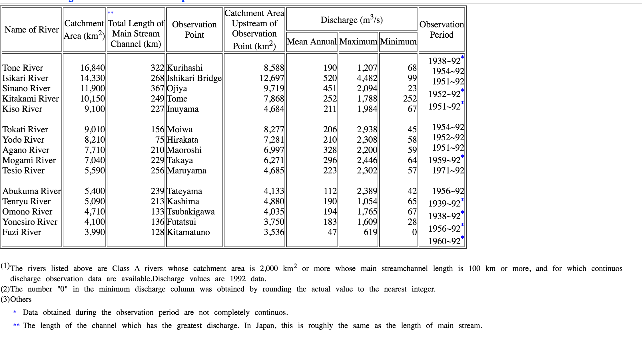
Discharge rates of major Japanese rivers. The Shinano is the third river listed, transliterated as “Sinano.”
Discharge rates of major Japanese rivers. The Shinano is the third river listed, transliterated as “Sinano.”
This image is from the Japanese Ministry of Land, Infrastructure, Transport, and Tourism.
This work is licensed under a Creative Commons Public Domain Mark 1.0 License.
Japan’s longest river, the Shinano, surges down a steep gradient, steeper than a number of the world’s great streams. It empties onto the broad, flat Echigo Plain, historically subject to floods. Risk is amplified by the great variation between peak, minimum, and average volumes of water.
The modern Okotsu project (1909–1922) lies at the heart of flood reduction efforts on the Echigo Plain. It has had a checkered history. Eighteenth-century proposals failed, a function of costs and downstream opposition by shippers and farmers who feared eventual collapse of the proposed weirs and destruction of their livelihoods. Finally begun in the early 1870s, the project was abandoned in 1875 for financial reasons. In 1927, downstream opponents’ fears of weir collapse were actually realized when hydraulic forces at the front of the weir undermined it. The collapse blocked all water flow to the main channel and sent all of Shinano’s waters through the diversion channel to the Sea of Japan. The failure stopped all traffic from Nagaoka to Niigata, and stopped the supply of water to some 27,300 hectares of paddy and to eight downstream towns and Niigata City. While downstream stakeholders loudly objected to the repair, redesign, and resurrection of the project, a new weir was completed in 1930. With improvements, the diversion channel has been in operation ever since, but created an engineering pattern that generated new, unanticipated risks.
External map. Link of Shinano River near Niigata City, Japan: https://www.google.com/maps/place/%E3%88%B1%E4%BF%A1%E6%98%8E%E7%94%A3%E6%A5%AD/@37.606079,138.846394,6737m/data=!3m1!1e3!4m5!3m4!1s0x0:0xf9641df7afc9294a!8m2!3d37.6060792!4d138.846394?hl=de
The success of the Okotsu project in preventing flooding along parts of the Shinano provided a model for heavy postwar reliance on diversionary channel construction on other parts of the Echigo Plain. Since the end of World War II, 17 additional drainage channels and tunnels have been built in this region alone. Civil engineers supplemented these efforts with new dike construction.
Ironically, flood control projects have resulted in an increase in the value of assets damaged by floods, a direct result of redefining risky areas as safe. Engineers and government bureaucrats planned hardware solutions to address a single, limited problem in ways that a) presumed the stability of other elements of the Shinano’s hydrological system and b) promoted investment. This limited vision contributed to new problems. The increase in economic losses suggests that flood amelioration efforts induced new stakeholders to invest in “safe” areas, thereby exposing themselves to unacknowledged flood hazards. For example, flood damage south of Niigata City in July 2004 resulted in significant part from riparian engineering. A modern dike, which made a new suburban housing development “safe,” collapsed when river water pressure pushed water under the new, high dikes and undermined its foundations. Another 300-year-old dike collapsed because a new, modern cement dike accelerated water pressure on the old dike, creating disaster in a hitherto safe area.
By redefining risky areas as safe, policy makers sought (successfully) to promote investment, which itself created new inundation risks from subsidence. After Nagoya, Niigata City is the fastest-sinking area of Japan. The primary cause? Increasing population and industrial density lead to more and more subsurface water being pulled up from underground. Much of the city today is below sea level. The smaller stream shown on the map is the Shinano and its drainage channel, along which are pink areas above sea level, the result of modern dike construction that elevates the riverbed above the surrounding land. What will happen if one of the larger dikes break, as others have done?
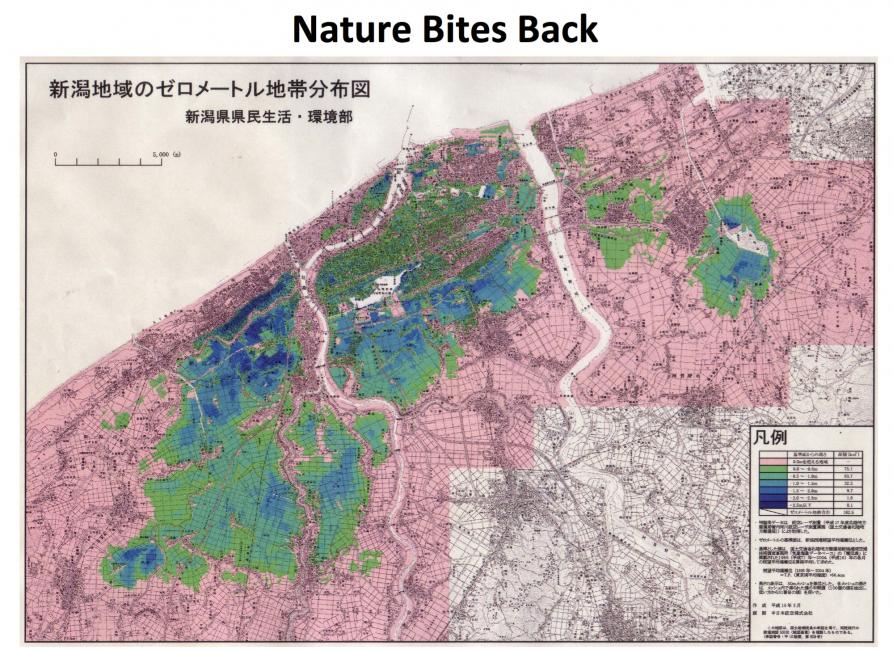
Patterns of subsidence, Niigata City: Blue and green areas are below sea level, the darker the color, the further they are located below sea level
Patterns of subsidence, Niigata City: Blue and green areas are below sea level, the darker the color, the further they are located below sea level
This map was commissioned by the Niigata Prefectural government. It is titled “Niigata chiiki no zero meetoru chitai bunpu zu.” Click here to view source.
This work is licensed under a Creative Commons Public Domain Mark 1.0 License.
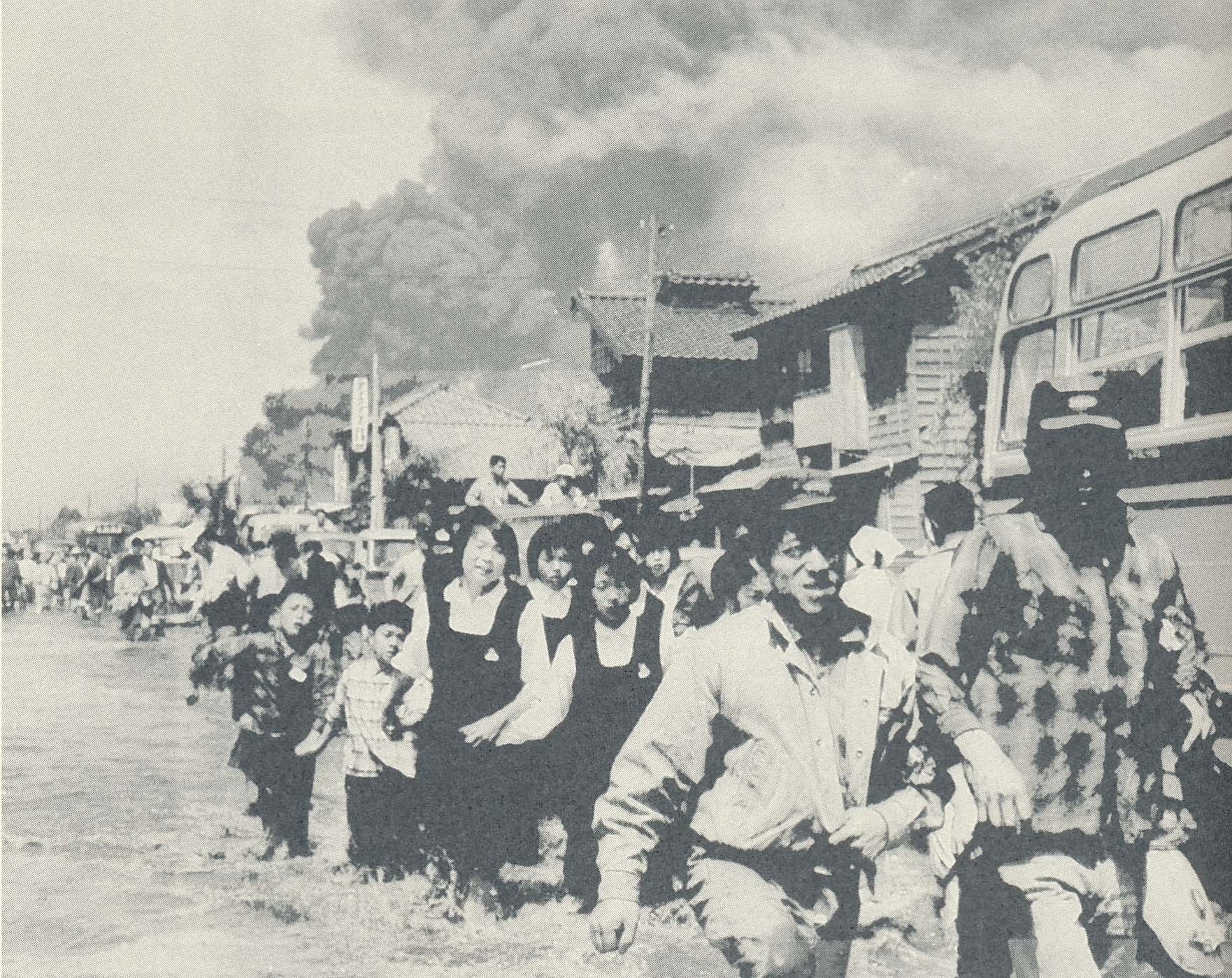
Further, residents of this area are subject to a special flood risk, from tsunami events, the impact of which is aggravated by subsidence linked to investments in newly identified safe areas. The tsunami caused by the 1964 earthquake surged far into the city. The waters did not drain for several weeks. With increased subsidence, more areas of the city will be at risk for inundation.
In sum, despite short-term measures of success in flood risk amelioration, by redefining disaster-prone areas of the lower Shinano as safe for residents and economic development, engineers and government have courted new disasters.

Tsunami-inundated Niigata City, 1964. This image was provided by Niigata Nippo Sha.
How to cite
Brown, Philip C. “Creating Safety, Courting Disaster on the Lower Shinano River, Japan.” Environment & Society Portal, Arcadia (Autumn 2017), no. 26. Rachel Carson Center for Environment and Society. doi.org/10.5282/rcc/7976.
ISSN 2199-3408
Environment & Society Portal, Arcadia
 This work is licensed under a Creative Commons Attribution 4.0 International License.
2017 Philip C. Brown
This refers only to the text and does not include any image rights.
Please click on an image to view its individual rights status.
- Brown, Philip C. “Reverse Flow: The Role of Built Environments in Shaping Disaster.” Technology and Culture 58, no. 1. (2017):170–181. doi:10.1353/tech.2017.0007.
- Proctor, Robert. “Agnotology: A Missing Term to Describe the Cultural Production of Ignorance [and Its Study].” In Agnotology: The Making & Unmaking of Ignorance, edited by Robert and Londa Schiebinger Proctor, 1–33. Stanford, CA: Stanford University Press, 2008.


