In the mid-eighteenth century, following the Bourbon Reforms, the Captaincy General of Chile developed a foundational urban-center policy to organize and concentrate the demographic distribution in their territories. As a result, in 1744, the Villa de San Francisco de la Selva was founded in the middle regions of Copiapó Valley, replacing the old Copiapó Town that dated from 1540. From the Villa’s foundation, the river and water governance were considered critical factors in the political equilibrium of colonial society in the valley. The valley and its river cut across the extreme dryness of the Atacama Desert that stretches from the Andes Mountains to the Pacific Ocean. This small wet strip offered refuge, wood, shade, water, and food to settlers and travelers in a region with a very arid climate and scarce rainfall.

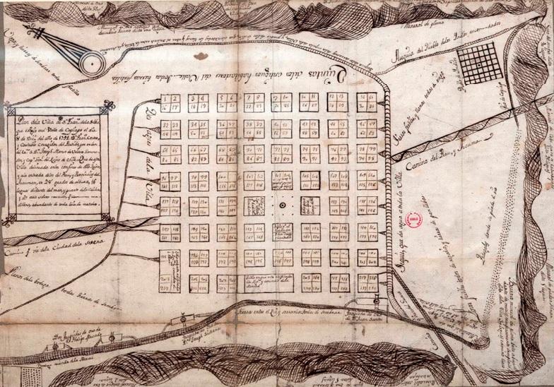
Cartography of Copiapó Valley in the late colonial period.
Cartography of Copiapó Valley in the late colonial period.
Map by Francisco Astudillo Pizarro.
 This work is licensed under a Creative Commons Attribution-NonCommercial-ShareAlike 4.0 International License.
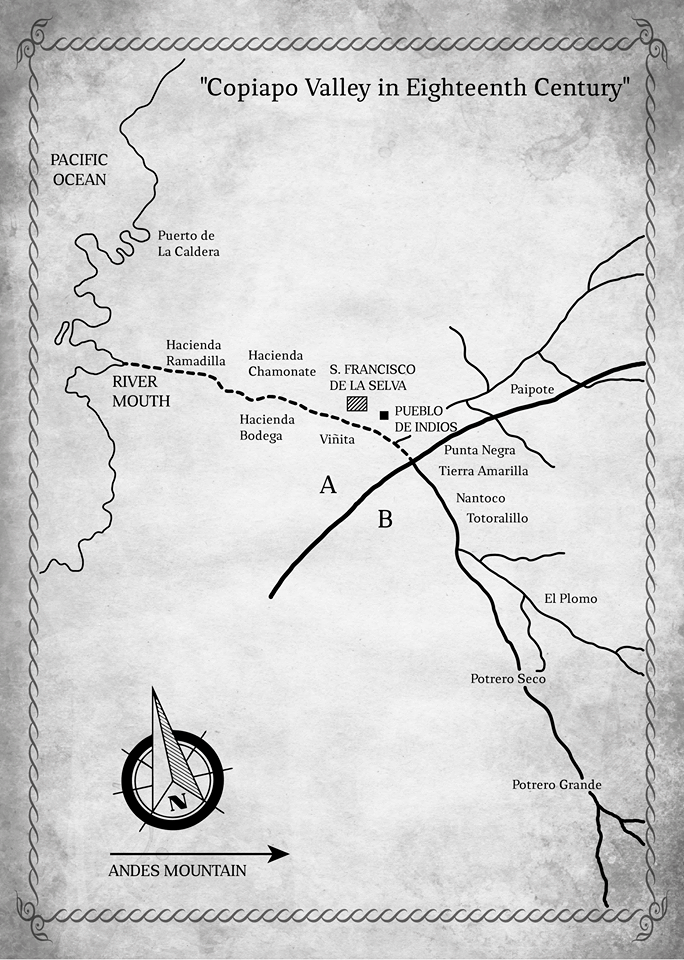
The local economy alternated crops with mining activity: both agricultural production and the large-scale mining activity belonged to the landowners of the highlands, among whom land ownership was concentrated and who mainly demanded water for productive purposes in the haciendas: Punta Negra, Tierra Amarilla, Nantoco, Potrero Grande, and Potrero Seco. All those were low-density population areas. This overlap between ownership of the means of production and the use of water expresses processes that demonstrate what Salazar (2003) called “colonial accumulation in Chile,” which explains the privileged position of estate owners in the valley as local political elites. The ownership of land also reflected the political power structure in the valley.
Meanwhile, both the Villa de San Francisco de la Selva and the Pueblo de Indios de San Fernando were located in the middle regions of the valley. The Villa—the headquarters of the cabildo (municipal council)—was inhabited by criollos (creole Chileans), merchants, laborers, and small landowners and accounted for 65% of the valley’s population, while the Pueblo de Indios, a smaller colonial reduction located a few kilometers to the east of the village, was inhabited by indigenous groups who were entrusted in the encomienda system and represented 8.9%. Together, these two urban settlements comprised about 74% of the valley’s population, who needed water for domestic, small-irrigation, and survival use—and among whom land ownership was fragmented.
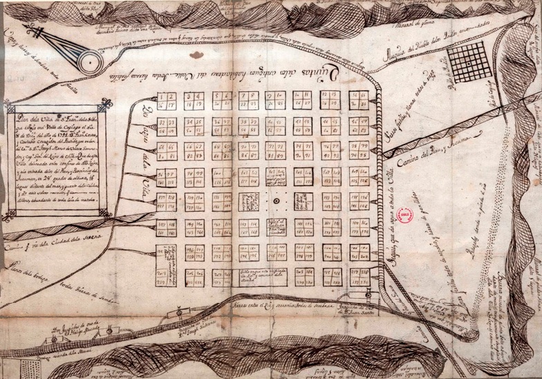
An image showing the Villa’s foundational planning, dating from 1744, shows water being channeled through traditional infrastructures, called “acequias” (irrigation canals), to the lots of both the Villa and the Pueblo de Indios, and proves the dependence of both settlements on surface water.
San Francisco de la Selva’s Foundational Planning.
San Francisco de la Selva’s Foundational Planning.
Unknown cartographer, c. 1744.
Courtesy of Archivo Nacional Histórico and Memoria Chilena.
 This work is licensed under a Creative Commons Public Domain Mark 1.0 License.
Water flows connected territories, topologies, economies, rules, and populations in fragile hydro-social balances, giving shape to a political regionality articulated around water and its use value as an element of contention and collective interest (Astudillo Pizarro 2018). Based on Latour’s Actor-Network Theory (ANT) (Latour 2008; Warf 2009), I argue that the river and water functioned as a central actor or nodal point in a dynamic sociospatial network.
The valley depended entirely on water circulation, and flows of water constituted the central public conflict in the valley and its settlements (Broll 1988). The river and water wove a network of uses and differential interests from the Andes Mountains to the lowlands of the river mouth. In the Copiapó River, a meltwater river, the water descends the slopes of the valley from the mountain range to the sea. This topographic condition was essential to implementing the watering rights. I here use the concept of topography to problematize the power asymmetries across the territory and the social structure in the valley.
Between 1762 and 1787, the middle regions of the valley (where Pueblo de Indios de San Fernando and Villa de San Francisco de la Selva were located) and the lowlands remained without water on several occasions due to the total hoarding of water flows for economic activities by the landowners in the highlands of the valley (Sayago 1874), who systematically took advantage of their geographical location. The dotted line in the image showing the valley’s cartography represents the sectors in which water stopped running, separating the highlands from the middle regions and lowlands.
The local cabildo managed the conflict and submitted its claims to the Real Audiencia (the central colonial institution), which systematically favored the plaintiffs’ neighbors in the middle regions, who claimed water as a common good and an inappropriable element whose flows should be guaranteed for life. However, all regulations and sanctions were evaded by the highland landowners.
In 1788, the governor general, Ambrosio O’Higgins, visited the area. He listened to all those involved, applied sanctions, and reaffirmed the mandated regulations that the highland landowners violated again. In 1801, residents in the middle regions initiated a lawsuit through the cabildo against Manuel de la Torre and Juan Bautista Sierralta, two landowners who had representation in the town hall, triggering a major political controversy.
Tired and disappointed by the ineffectiveness of the institutional route to solving their problems, the indigenous inhabitants of Pueblo de Indios, led by Cacique Pablo Tacquía, took justice into their own hands, claiming to “liberate” water flows and threatening to set fire to the big landowner estates (Sayago 1874; Berrios and Lucero 2011). As a result, the central colonial authorities imposed sanctions and control measures to restore water flows, simultaneously starting a judicial process against the leaders of the riot.
Even when the sociopolitical dynamics of mobilization occurred in urbanized centers, the analysis shows that it is necessary to address a broader and systemic analytic unit, such as the basin as a whole, when inquiring into the relations between social classes, ethnic groups, and political estates through topographic networks of power.
How to cite
Astudillo Pizarro, Francisco. “Water Flows and Topographic Networks of Power: Social Struggles for Water in the Copiapó Valley in the Eighteenth Century .” Environment & Society Portal, Arcadia (Spring 2020), no. 2. Rachel Carson Center for Environment and Society. doi.org/10.5282/rcc/8981
ISSN 2199-3408
Environment & Society Portal, Arcadia
 This work is licensed under a Creative Commons Attribution 4.0 International License.
2020 Francisco Astudillo Pizarro
This refers only to the text and does not include any image rights.
Please click on the images to view their individual rights status.
- Astudillo Pizarro, Francisco. “De la regionalidad política a la regionalidad económica: Agua, minería y território em Atacama (Siglos XVIII–XIX).” Boletín Americanista 77 (2018): 81–103.
- Berrios Drolett, Francisco, and Juani Lucero Villavicencio. “Antecedentes Históricos sobre el Uso del Agua y sus Conflictos en el valle de Copiapó a partir del Siglo XVIII.” Boletín Museo Regional de Atacama 2, no. 2 (2011): 34–40.
- Broll, Julio. “La Lucha por el agua en el valle de Copiapó (1744-1810).” In Copiapó Siglo XVIII, edited by Julio Broll and Jorge Pinto, 127–46. Valparaíso: Universidad Católica de Valparaíso, 1988.
- Latour, Bruno. Reassembling the Social: An Introduction to Actor-Network Theory. Oxford: Oxford University Press, 2005.
- Salazar, Gabriel. Historia de la acumulación capitalista en Chile: apuntes de clase. Santiago: LOM Editores, 2003.
- Sayago, Carlos María. Historia de Copiapó. Copiapó: Imprenta el Atacama, 1874.
- Warf, Barney. “From Surfaces to Networks.” In The Spatial Turn. Interdisciplinary Perspectives, edited by Barney Warf and Santa Arias, 59–76. New York: Routledge, 2009.


