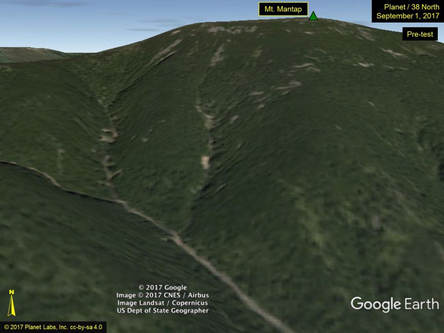
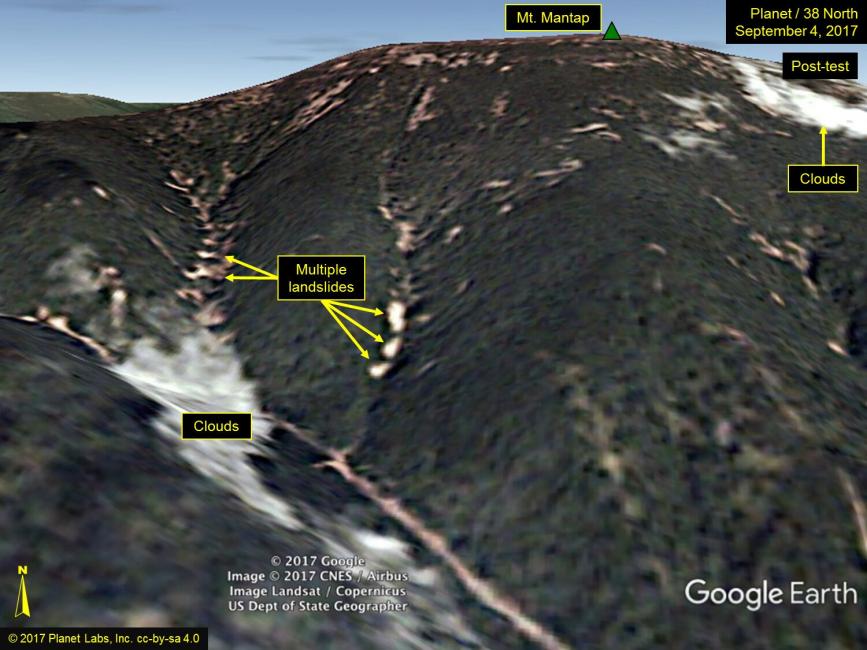
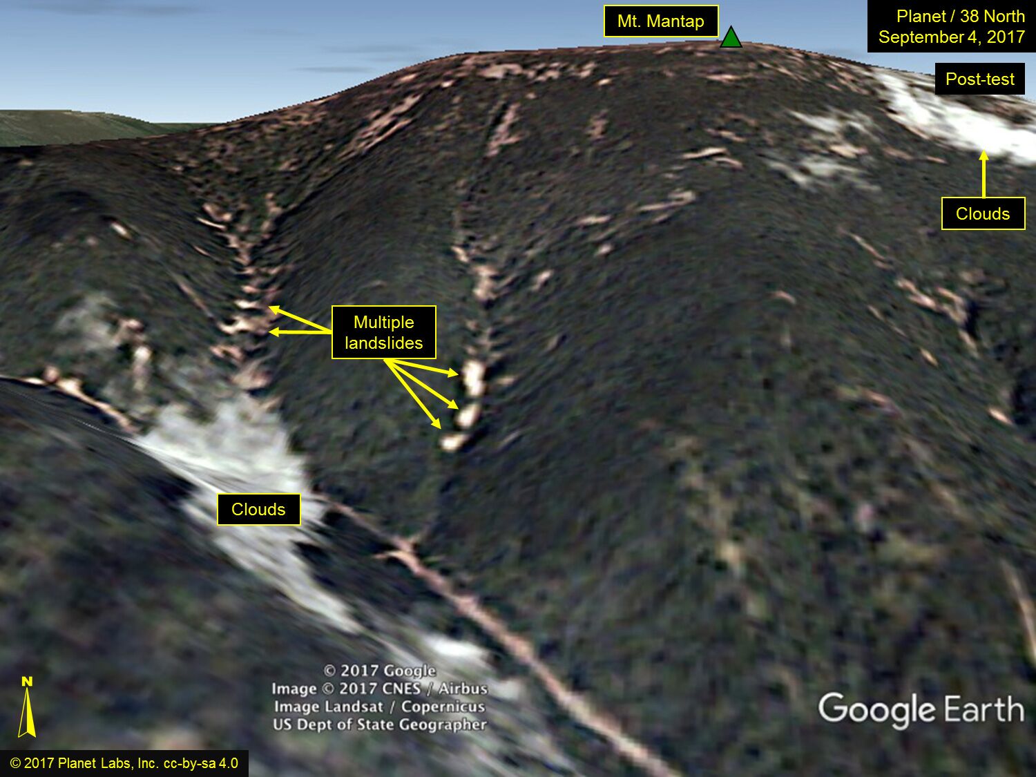
On 3 September 2017, the earth shifted. Seismic activity registering 6.1 on the Richter scale indicated a major geophysical event had taken place, one strong enough to change the shape of mountains. On that day, North Korea exploded a nuclear device at the Punggye-ri Nuclear Test Site inside Mount Mantap (Figure 1). Estimated to be at least 100 kilotonnes, it was the largest nuclear device detonated by North Korea to date (Figure 2). Satellite pictures from before and after the event provide visual evidence of the test’s power to alter the lay of the land (Figures 3 and 4). The most obvious immediate effect was subsidence over 34 hectares of Mantap’s western slope—indicated by the appearance of bare patches in the mountain’s vegetation after the test—and a resulting loss of one to three meters of the peak’s total elevation. Long-term, Mantap may suffer from “tired mountain syndrome,” in which its weakened geological structure could result (and may have already resulted) in the collapse of the test tunnels and in seepage of radioactive material into the air, soil, and water.

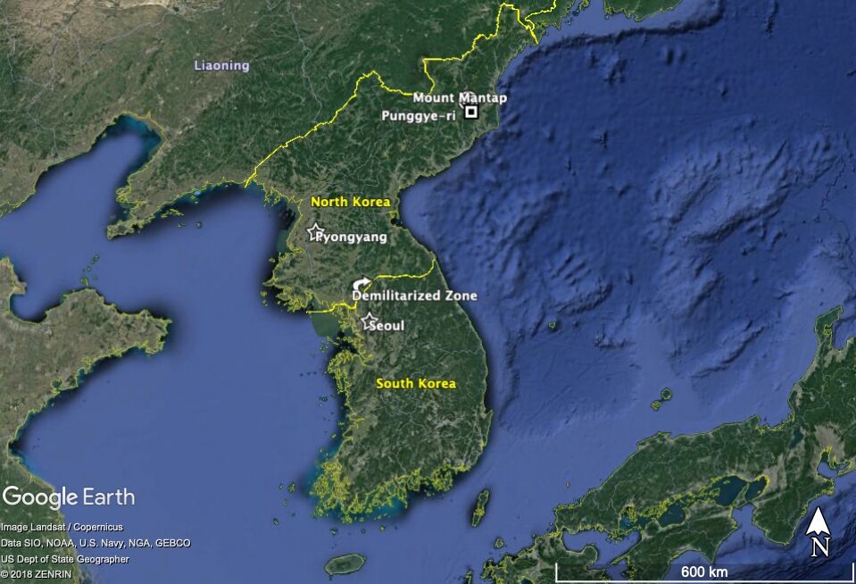
Fig. 1. The Korean Peninsula with Mount Mantap and the Punggye-ri Nuclear Testing Site identified near the top center. Stars denote the capital cities of both Koreas. The yellow line marked by an arrow in the center of the image marks the Demilitarized Zone.
Fig. 1. The Korean Peninsula with Mount Mantap and the Punggye-ri Nuclear Testing Site identified near the top center. Stars denote the capital cities of both Koreas. The yellow line marked by an arrow in the center of the image marks the Demilitarized Zone.
© Google
Image Landsat / Copernicus
Data SIO, NOAA, U.S. Navy, NGA, GEBCO
Us Dept of State Geographer
© 2018 Zenrin
The copyright holder reserves, or holds for their own use, all the rights provided by copyright law, such as distribution, performance, and creation of derivative works.
As dramatic as the incident was, Mantap’s reshaping represents only the most recent example of how military activities have physically transformed Korea and its environment. Throughout the twentieth century, the Korean peninsula epitomized what scholars call militarized landscapes—those places in whole or part mobilized to support military aims. Early in that period, Japan fought with both Russia and China to control Korea, ultimately claiming the peninsula as a formal colony in 1910. For the next thirty years, Japan forcibly marshaled Korea’s human and natural resources to extend its imperial power across Asia and the Pacific. The peninsula’s forests, mineral reserves, and waterways powered the factories and transportation networks the empire built to achieve its military goals; Korea’s agricultural lands fed the Japanese army that was fighting to expand Japan’s power in Manchuria and China. Depleted forests, eroded mountains, and dammed rivers evidenced the militarization of Korea’s landscape.

Fig. 2. Chart comparing seismic disturbance associated with all North Korean nuclear tests, 2006–2017.
Fig. 2. Chart comparing seismic disturbance associated with all North Korean nuclear tests, 2006–2017.
© NORSAR
This work is used by permission of the copyright holder.
This militarization process intensified, rather than diminished, with Japan’s defeat in 1945. While the end of World War II promised the return of peace and a sovereign Korean state, larger geopolitical forces complicated that transition and resulted in a peninsula physically and politically divided at the 38th parallel. Several years of bitter internecine conflict ensued, followed by all-out war when North Korean forces invaded South Korean territory on 25 June 1950. For the next three years, brutal armed conflict raged back and forth across the peninsula, leaving nearly 10 percent of Korea’s population dead and at least 60 percent of its forests destroyed. A massive refugee crisis compounded wartime disruptions in agriculture and placed additional demands on compromised urban and rural infrastructures. The armistice signed on 27 July 1953 provided only for a cease-fire, so the two Koreas remain (as of this writing) officially at war, still separated at the 38th parallel by the incongruously named Demilitarized Zone (DMZ). While the armistice brought some measure of peace, intense ideological competition and occasional outbreaks of violence between North and South Korea ensure that the peninsula remains one of the most militarized landscapes on Earth.
© 2017 Google
Image © 2017 CNES / Airbus Image Landsat / Copernicus
US Dept of State Geographer.
Image edited by Planet Labs, Inc.
The copyright holder reserves, or holds for their own use, all the rights provided by copyright law, such as distribution, performance, and creation of derivative works.
Figs. 3 and 4. Mt. Mantap before and after the 3 September 2017 nuclear test. This view illustrates the angle of slope of the terrain.
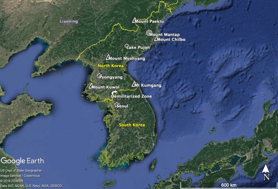
It is in this context that we must understand North Korea’s nuclear program and the related changes to Mount Mantap’s terrain. Decades of conflict have heightened North Korea’s sense of urgency regarding its national security, resulting in actions that override long-standing cultural and legal proscriptions against the destruction of nature. Koreans—north and south of the DMZ—ascribe both historical and spiritual meaning specifically to mountains, many of which play important roles in local legends and religious practices. Mountains also figure prominently in Korean environmental preservation. Of the six national parks in North Korea, for example, five protect individual mountain peaks (Figure 5). The most significant of these, Mount Paektu, sits only 114 kilometers northwest of Mount Mantap. Beyond the cultural contradiction, the nuclear program also contravenes Article 7 of North Korea’s Environmental Protection Law (1986), which explicitly prohibits the development, testing, and use of nuclear and chemical weapons on the Korean peninsula and pledges to fight any such activity in the region. And yet, North Korea felt compelled to become a nuclear power, undermining the integrity of Mount Mantap in the process.
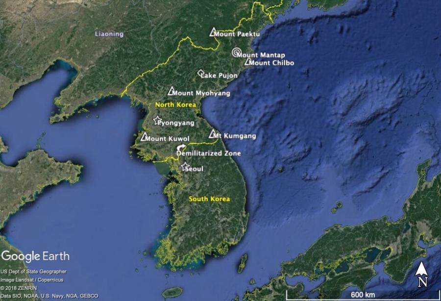
Fig. 5. Map showing locations of North Korea’s six national parks (denoted by triangles or squares) and Mount Mantap, the location of the 3 September 2017 nuclear test (near top center). Mount Paektu (top center), a sacred site for many Koreans, sits only 114 km northwest of Mount Mantap.
Fig. 5. Map showing locations of North Korea’s six national parks (denoted by triangles or squares) and Mount Mantap, the location of the 3 September 2017 nuclear test (near top center). Mount Paektu (top center), a sacred site for many Koreans, sits only 114 km northwest of Mount Mantap.
© Google
US Dept of State Geographer
Image Landsat / Copernicus
© 2018 Zenrin
Data SIO, NOAA, U.S. Navy, NGA, GEBCO
The copyright holder reserves, or holds for their own use, all the rights provided by copyright law, such as distribution, performance, and creation of derivative works.
The nuclear explosion inside Mount Mantap and the landslides on its surface may have taken mere minutes to unfold, but they were a century in the making. They may also represent a turning point away from that history. The 2017 nuclear test heightened global concerns over North Korea’s military plans and regional fears about the environmental fallout; yet, less than a year later, a historic meeting occurred between North Korea’s Supreme Leader Kim Jong-un and South Korea’s President Moon Jae-in, resulting in the Panmunjom Declaration for Peace, Prosperity, and Unification of the Korean Peninsula. The Declaration calls for an official end to the Korean War, improvements in inter-Korean relations, and the denuclearization of the peninsula. If achieved, these objectives could set the stage for the peninsula’s demilitarization as well. The events at Mount Mantap may symbolize Korea’s militarized history, but may also usher in a new era of peace and prosperity for the Korean peninsula.

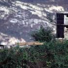
Fig. 6. A North Korean observation post in the Demilitarized Zone.
Fig. 6. A North Korean observation post in the Demilitarized Zone.
Photograph by Jeffrey Allen, 20 October 1998.
Accessed via PICRYL on 14 March 2019. Click here to view source.
 This work is licensed under a Creative Commons Public Domain Mark 1.0 License.
How to cite
Brady, Lisa M. “Mountain, Militarized: North Korea, Nuclear Tests, and Nature” Environment & Society Portal, Arcadia (Spring 2019), no. 8. Rachel Carson Center for Environment and Society. doi.org/10.5282/rcc/8496.
ISSN 2199-3408
Environment & Society Portal, Arcadia
 This work is licensed under a Creative Commons Attribution 4.0 International License.
2019 Lisa Brady
This refers only to the text and does not include any image rights.
Please click on an image to view its individual rights status.
- Brady, Lisa M. “Korea’s Green Ribbon of Hope: History, Ecology, and Activism in the DMZ.” Solutions 3, no. 1 (2012): 94–98. (Link)
- Cumings, Bruce. North Korea: Another Country. New York: The New Press, 2004.
- Fedman, David Abraham. “The Saw and the Seed: Japanese Forestry in Colonial Korea, 1895–1945.” PhD Diss., Stanford University, 2015.
- Kim, Eleana. “The Flight of the Cranes: Militarized Nature at the North Korea-South Korea Border.” In “Asian Environments: Connections across Borders, Landscapes, and Times,” edited by Ursula Münster, Shiho Satsuka, and Gunnel Cederlöf. RCC Perspectives 2014, no. 3: 65–70. doi:10.5282/rcc/6339.
- Pearson, Chris, Peter Coates, and Tim Cole. Militarized Landscapes: From Gettysburg to Salisbury Plain. London: Continuum, 2010.
- Thomas, Julia Adeney. “The Exquisite Corpses of Nature and History: The Case of the Korean DMZ.” The Asia-Pacific Journal 43, no. 3 (2009): 1–17. (Link). Also included in Militarized Landscapes, edited by Chris Pearson, Peter Coates, and Tim Cole, 151–70. London: Continuum, 2010.


