Examining the impact of ecological and geographical features on the configuration of political space within a region adds a compelling dimension to historical inquiry. A noteworthy case study is the transformation of Bihar, situated in the riverine landscape of the mid-Ganga basin in South Asia, into a distinct province in the sixteenth century. This case study illustrates the intricate interplay between geography and the political constructs that define a region.

Photo of Sher Shah’s mausoleum in Sasaram, the place where he was born.
Sher Shah of the Sur dynasty emerged as a prominent Afghan ruler in the sixteenth century. His deep-rooted connection to the riverine landscape of the mid-Ganga basin, where he grew up, allowed him to perceive its vast potential. He had inherited his father’s jagir, a revenue administration area, situated south of the Ganga in Bihar at Sasaram. His biographer Abbas Khan Sarwani has provided insights into his revenue administration, emphasizing its alignment with the local ecology. The Ganga River, flowing through Bihar, is met by numerous rivers from both the northern and southern regions. These rivers experience annual floods, significantly shaping settlement patterns, agricultural methods, and economic pursuits. The floodplains of these rivers were owned by different petty local chiefs. Sher Shah orchestrated the unification of these disparate local chiefs in the region, laying the foundation for Afghan rule in the mid-Ganga basin.

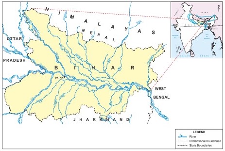
The Mid-Ganga Plain features the congregation of many rivers with the Ganga in Bihar.
The Mid-Ganga Plain features the congregation of many rivers with the Ganga in Bihar.
© Vipul Singh. Used by permission. Published in Vipul Singh. “Where Many Rivers Meet: River Morphology and Transformation of Pre-modern River Economy in Mid-Ganga Basin, India,” in Environmental History in the Making, vol. 1, Explaining, ed. Estelita Vaz, Cristina Joanaz de Melo, Lígia M. Costa Pinto, 187–206 (Cham: Springer International, 2017), p. 192.
The copyright holder reserves, or holds for their own use, all the rights provided by copyright law, such as distribution, performance, and creation of derivative works.
Khan Sarwani has documented how Sher Shah’s understanding transcended the river ecology of the mid-Ganga region. Sher Shah adeptly utilized the different river channels coming from the Himalayas in the north and the Deccan plateau in the south to envision a cohesive political entity. He knew that the expansive rivers, characterized by broad floodplains and annual inundation, ultimately converged with the Ganga, leading communities to strongly identify themselves with the river. The confluence of a similar river ecology and a culturally cohesive population served as defining markers for his vision of a province. Under his rule, the foundational concept of Bihar as a province was conceived.
As his authority solidified and expanded westward, the imperative to establish his imperial capital in Delhi became evident. With the Sur dynasty’s dominion encompassing Delhi, Bihar was officially designated as a distinct province in 1540, with Patna as its capital. In other contemporary historical records, we unearth this perceptive foresight. An account in Tāikh-i Dāudi recounts an intriguing episode in Bihar’s historical narrative, specifically preceding the Battle of Chausa in 1539 between Sher Shah and the Mughal ruler Humayun, who aspired to exert his dominion over the entire eastern expanse. At this juncture, Sher Shah, in a noteworthy gesture, initially offered to relinquish control over the mid-Ganga region of Bihar, which extended from the Karmnasa River in the west to the eastern periphery, marked by Garhi, which bordered Bengal. While the diplomatic negotiations between Sher Shah and Humayun ultimately faltered and culminated in armed conflict, the salient point that emerges from these historical accounts is the preexistent conceptualization of Bihar as a distinct regional entity.

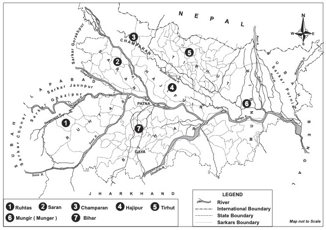
Map of the seven districts of Bihar province divided on the basis of the rivers.
Map of the seven districts of Bihar province divided on the basis of the rivers.
© Vipul Singh. Used by permission. Published in Vipul Singh, Speaking Rivers: Environmental History of a Mid-Ganga Flood Country, 1540–1885 (Delhi: Primus Books, 2018), p. 49.
The copyright holder reserves, or holds for their own use, all the rights provided by copyright law, such as distribution, performance, and creation of derivative works.
Following the demise of Sher Shah and the subsequent weakening of Afghan control over Bihar, the Mughal ruler Akbar assumed authority over the region. In the late sixteenth century, noted Persian chronicler Abu’l Fazl delineated Garhi as the easternmost limit of Bihar. He realized that the mid-Ganga region was unique and very difficult to control. The web of rivers created obstacles for his powerful cavalry. So, following Sher Shah’s conception, he designated Bihar as a distinct suba or province in 1580. This reconfiguration served the dual purpose of facilitating effective governance of the region and endowing it with a degree of administrative autonomy. This strategic move aligns with the earlier ecological conception of Sher Shah, as it created a province characterized by ecological and cultural homogeneity.
Bihar province was organized into seven administrative districts known as sarkars. The demarcation of these districts was heavily influenced by the region’s prominent rivers, underscoring the pivotal role of geography in the administrative structure of the time. Each district was linked to a specific river floodplain, contributing to its high agricultural productivity. Mughal rulers appointed distinct revenue officers, therefore, to oversee revenue collection in each district. The river channels served as conduits for internal trade and grain exports. The Ganga River, with its navigable routes and extensive connectivity to all districts, played a pivotal role in facilitating the transportation of goods, enhancing the region’s economic activities and trade networks.

James Rennell’s Map of Bihar and Bengal in 1776. It is one of the first accurate maps laid out from primary surveys done by James Rennell after the East India Company got the revenue collection rights of Bihar, Bengal, and Orissa from the Mughals.
James Rennell’s Map of Bihar and Bengal in 1776. It is one of the first accurate maps laid out from primary surveys done by James Rennell after the East India Company got the revenue collection rights of Bihar, Bengal, and Orissa from the Mughals.
Accessed via Wikimedia Commons. Click here to view the source.
 This work is licensed under a Creative Commons Public Domain Mark 1.0 License.
The establishment of Bihar as a distinct political and administrative entity in history prominently highlights its reliance on ecological attributes, particularly the intricate network of rivers. This noteworthy aspect underscores the profound historical importance of the region’s hydrographic characteristics. Sher Shah was the first ruler to recognize Bihar as a distinct ecopolitical region. It was within this ecologically coherent environment that Sher Shah’s vision for his principality began to take shape, a testament to the profound influence of ecology on the course of historical developments. This conception proved effective when the Mughals sought to incorporate the fertile and humid plains of the Ganga into the political economy. Bihar retained its distinct provincial status until 1765, at which point control over the Mughal provinces of Bengal, Bihar, and Orissa was officially transferred to the East India Company. In the early twentieth century, when the government contemplated dividing Bengal for administrative and political reasons, Bihar regained its separate status as a province. The primary considerations for this separation were the similarities in physical features, climate, crops, and manners within the region.
How to cite
Singh, Vipul. “Ecopolitical Space in a Riverine Landscape of South Asia.” Environment & Society Portal, Arcadia (Spring 2024), no. 3. Rachel Carson Center for Environment and Society. https://www.environmentandsociety.org/node/9810
ISSN 2199-3408
Environment & Society Portal, Arcadia
 This work is licensed under a Creative Commons Attribution 4.0 International License.
2024 Vipul Singh
This refers only to the text and does not include any image rights.
Please click on an image to view its individual rights status.
- Abu’l-Fazl ’Allami. A’in-i Akbari. Vol. 2. Translated by Heinrich Blochmann. Delhi: LPP, 2014.
- Ambashthya, B. P., ed. Beames’s Contribution to the Political Geography of the Subahs of Awadh, Bihar, Bengal and Orissa in the Age of Akbar. Patna: Janaki Prakashan, 1976.
- Aounshuman, Ashok and Śrīkānta, eds. The Making of a Province: Select Documents on the Creation of Modern Bihar, 1874–1917. Patna: Directorate of Archives, Government of Bihar, 2013.
- Elliot, Henry Miers. “Tārīkh-i Dāudī, of Ἀbdu-lla.” In The History of India, as Told by Its Own Historians: The Muhammadan Period. Vol. 4. To the Year A.D. 1450, edited by John Dowson, 434–513. Cambridge: Cambridge University Press, 2013. doi:10.1017/CBO9781139507165.
- Jha, Murari Kumar. “The Political Economy of the Ganga River: Highway of State Formation in Mughal India, c.1600–1800.” Ph.D. diss., Leiden University, 2013. https://hdl.handle.net/1887/20931.
- Sarwani, Abbas Khan. Tārikh i-Sēr Sāhi. Translated by Brahmadeva Prasad Ambashthya. Patna: Kashi Prasad Jayaswal Research Institute, 1974.
- Singh, Vipul. Speaking Rivers: Environmental History of Mid-Ganga Flood Country, 1540–1885. Delhi: Primus Books, 2018.


