
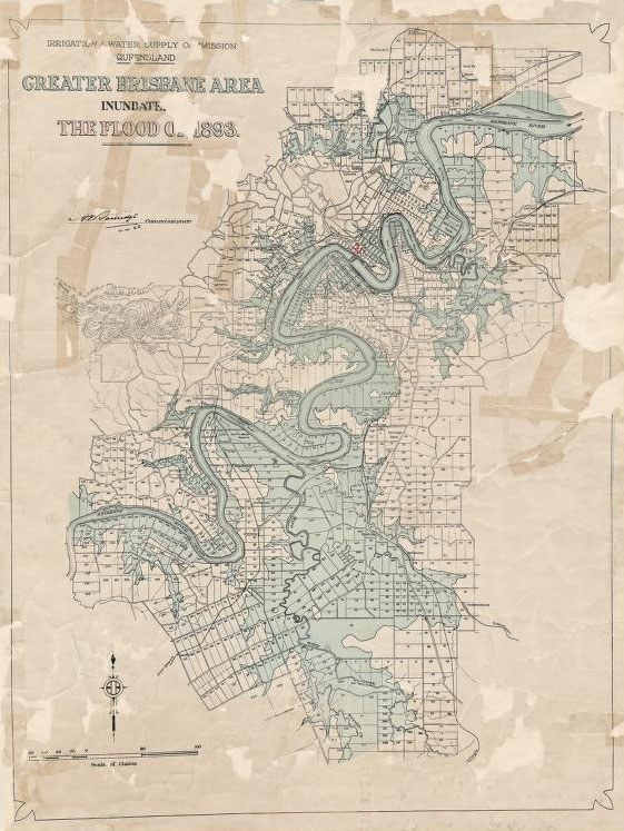
Greater Brisbane area inundated in the flood of 1893
Greater Brisbane area inundated in the flood of 1893
Irrigation & Water Supply Commission Queensland. Brisbane, Queensland: The Commission, 1928. Image Courtesy of State Library of Queensland.
 This work is licensed under a Creative Commons Public Domain Mark 1.0 License.
In 1892–93 Queensland experienced one of the hottest summers since British colonization in 1824, resulting in severe drought in the western districts. Relief came with an especially wet season in 1893, caused by what is now understood as a strong La Niña event. Brisbane, the state capital, experienced extreme rainfall with 1,025.9 mm falling at the Brisbane Regional Office in February alone. This caused three floods in the Brisbane River; the first peaking on 5 February, the second on 12 February, and the third on 19 February. The middle flood was comparatively minor, but the first reached 8.35 meters and the third 8.09 meters in the city center. These floods remain Brisbane’s second- and third-highest recorded floods, surpassed only in 1841 by an 8.43-meter flood. As such, the 1893 floods remain the benchmark that still determines the city’s water supply and flood mitigation strategies.
The 1893 floods claimed 35 lives, a significant number in a population of 100,000. An estimated 350 hectares in South Brisbane and 130 hectares in North Brisbane were submerged. The Indooroopilly and Victoria Bridges were destroyed, leaving the city without a cross-river bridge for two years. Water submerged almost two-thirds of the Brisbane business district, reaching a depth of 4.8 meters in places, lapping verandah tops. In South Brisbane, only the roofs of buildings could be seen, peeking out of miles of unbroken water. February’s Town and Country Journal reported that Stanley Street, South Brisbane’s main thoroughfare, had become “one long stretch of ruin and desolation.”

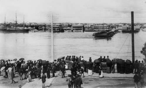
Victoria Bridge, connecting north and south Brisbane, destroyed by floods
Victoria Bridge, connecting north and south Brisbane, destroyed by floods
Photo courtesy of State Library of Queensland.
This work is licensed under a Creative Commons Public Domain Mark 1.0 License.

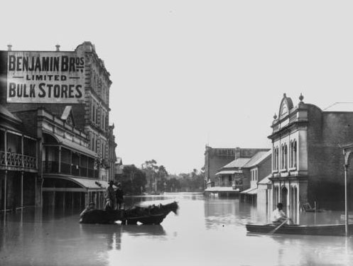
Edward and Mary Streets, 1893 floods
Edward and Mary Streets, 1893 floods
Photo courtesy of State Library of Queensland.
This work is licensed under a Creative Commons Public Domain Mark 1.0 License.
The river’s floodwaters ignored class distinctions, with the Maryborough Chronicle reporting that “cottage, bungalow, and mansion” vanished equally under the floodwaters. For example, in two South Brisbane local council wards, 198 buildings were destroyed and a further 67 damaged, at an estimated cost of £48,985. In Orleigh and Hill End Estates in the suburb of West End, 30 houses (approximately two-thirds) disappeared. Railway lines and roads were destroyed and the port closed. As fears rose about the threatened water supply, Brisbane was left without gas and electric light. The floods created enormous social problems, with homelessness, destitution, hunger, and unemployment high on the list. The cost of the damage was calculated as between £1 and £2 million, further crippling a weakened economy in the throes of an economic depression.

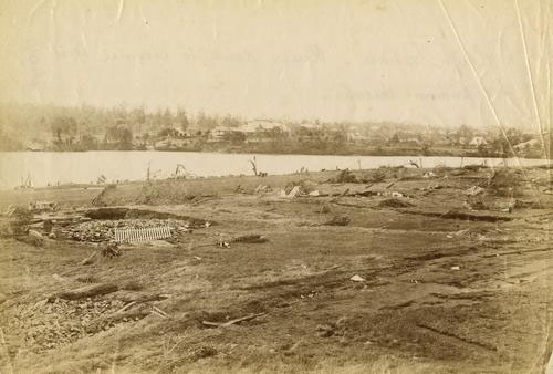
Homes in Orleigh Estate were washed away in 1893
Homes in Orleigh Estate were washed away in 1893
Photo courtesy of State Library of Queensland.
This work is licensed under a Creative Commons Public Domain Mark 1.0 License.
Descriptions of the flooding reveal a sensory overload. Newspapers recounted the noise—the roar of the floodwaters, the crash of debris, and “heart-rending screams.” Journalists vividly recorded the devastation and suffering. Smell overwhelmingly dominated settlers’ recollections with typical accounts referring to the “terrific” stench of the receding flood and the “foul smelling mud.” The miasma of floodwaters and mud, full of dead animals, debris, and raw sewerage in Queensland’s February subtropical heat, would no doubt have been memorable.
The floods changed the human relationship with the river. Previously viewed as a benign economic resource, the Brisbane River now became the enemy of progress. Reflecting international responses and linguistic trends, the public called on its government to “tame,” “harness,” and “control” the river with engineering structures to provide perceived environmental security. The 1893 floods accelerated a program of engineering interventions that included dredging, truncating bends, building training walls, and ultimately the completion of Somerset Dam in the catchment in 1959.
Controlling the river by dam construction in response to these floods, rather than implementing land use management for hazard reduction, set a path of dependency on dams that continues today.
How to cite
Cook, Margaret. “A Legacy of Brisbane’s Benchmark Floods of 1893: Creating Dam Dependence.” Environment & Society Portal, Arcadia (Spring 2017), no. 9. Rachel Carson Center for Environment and Society. doi.org/10.5282/rcc/7870.
ISSN 2199-3408
Environment & Society Portal, Arcadia
 This work is licensed under a Creative Commons Attribution 4.0 International License.
2017 Margaret Cook
This refers only to the text and does not include any image rights.
Please click on an image to view its individual rights status.
- Cook, Margaret. “Damming the ‘Flood Evil’ on the Brisbane River.” History Australia 13, no. 4 (2016): 540–556.
- O'Gorman, Emily. Flood Country: An Environmental History of the Murray-Darling Basin. Melbourne: CSIRO Publishing, 2012.
- Mauch, Christof, and Christian Pfister, eds. Natural Disasters, Cultural Responses: Case Studies toward a Global Environmental History. Lanham: Lexington Books, 2009.
- Bankoff, Greg, George Frerks, and Dorothea Hilhorst. Mapping Vulnerability: Disasters, Development, and People. London: Earthscan, 2004.
- Powell, J. M. Plains of Promise, Rivers of Destiny: Water Management and the Development of Queensland, 1824–1990. Brisbane: Boolarong, 1991.
- Webster, Barbara. Marooned: Rockhampton’s Great Flood of 1918. Brisbane: Cooperative Research Centre for Coastal Zone, Estuary and Waterway Management, 2003.
- Whitmore, Raymond. Hydraulic Henderson: Water Resources Pioneer. Brisbane: Engineers Australia, 2009.


