The town of Rockport and the city of Gloucester form Cape Ann, a rocky peninsula on the coast of northern Massachusetts. In the 1800s, Finnish granite workers emigrated to Rockport and armored the coast with breakwaters, creating a series of safe harbors to protect the fishing and shipbuilding industries there. The availability of quarried granite and the construction of hard infrastructure embedded the fortified coast in the Cape’s cultural imaginary (Babson 1860). Today, Rockport’s coastal development is subject to new vulnerabilities due to climate change, particularly sea level rise and increasingly severe storm events.

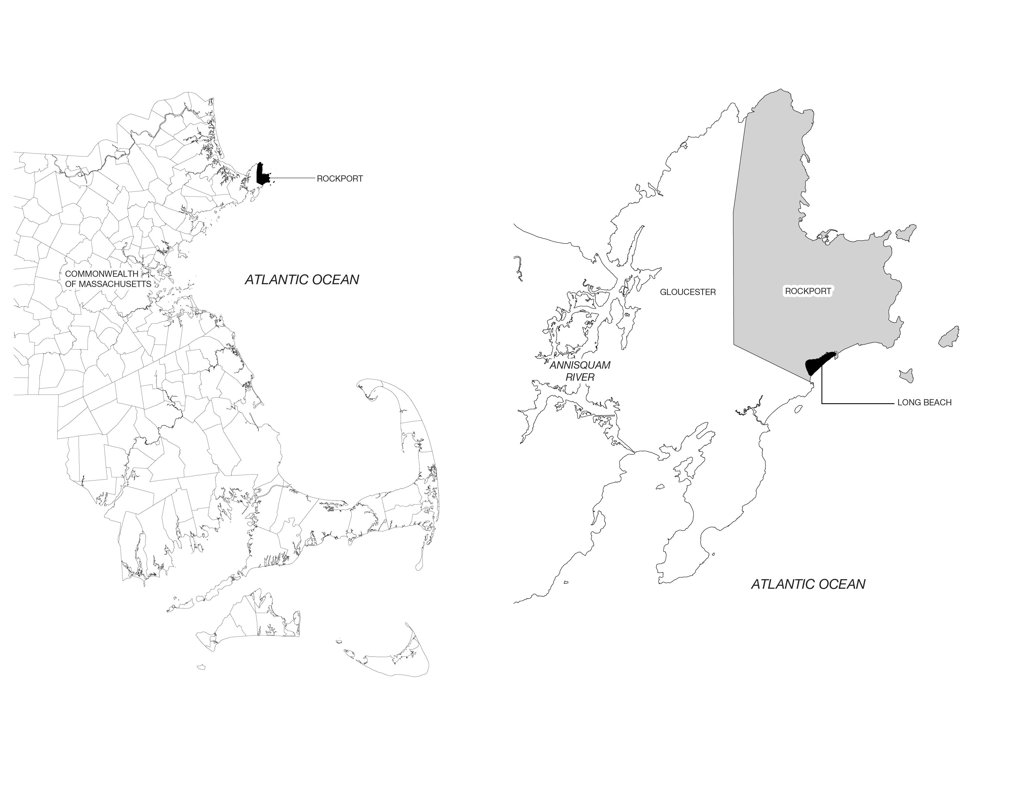
Locator maps of Long Beach. The map on the left shows the location of the town of Rockport in the Commonwealth of Massachusetts. The map on the right shows the location of Long Beach in the town of Rockport, as well as the Annisquam River, which separates West Gloucester and Rockport from mainland Massachusetts.
Locator maps of Long Beach. The map on the left shows the location of the town of Rockport in the Commonwealth of Massachusetts. The map on the right shows the location of Long Beach in the town of Rockport, as well as the Annisquam River, which separates West Gloucester and Rockport from mainland Massachusetts.
Maps by Kira Clingen
 This work is licensed under a Creative Commons Attribution 4.0 International License.
These vulnerabilities are especially clear in Long Beach, a neighborhood on Rockport’s eastern coast. In the early 1900s, 149 seasonal cottages and accessory buildings were constructed on top of the sandy spit barrier beach. A seawall was constructed to protect the cottages and fill was dumped on the dune system, which had previously shifted with the tides and seasons for thousands of years. Sand has scoured the seawall over past decades, reducing the area of public sandy beach (Applied Coastal Engineering and Research 2014). The seawall, parts of which were constructed in 1931 and 1959, has also been damaged by a series of nor’easters that threaten its structural stability (Long Beach Options Committee 2022: 8–9).
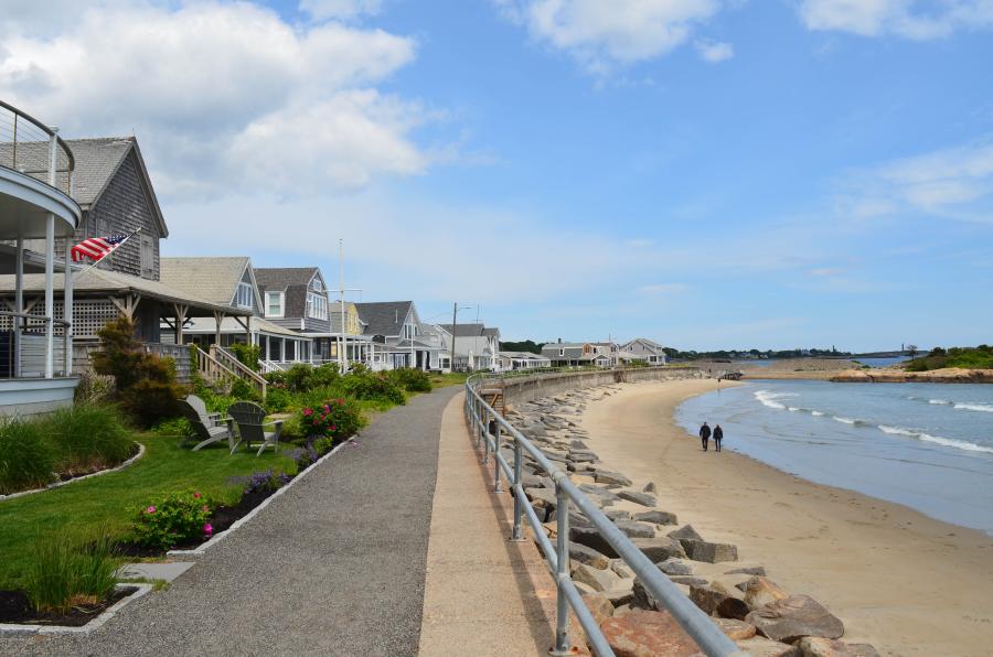
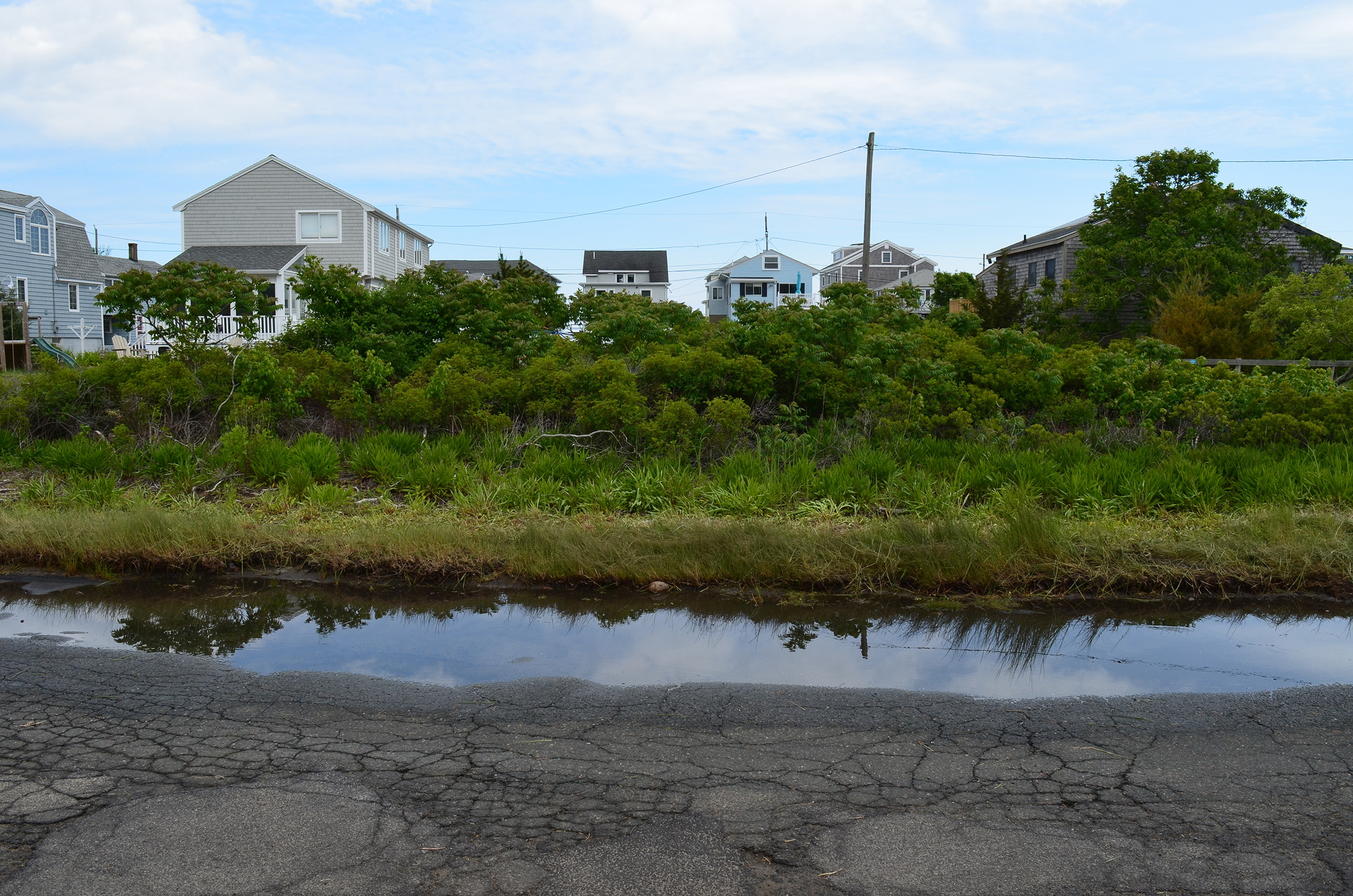
The yards in front of many cottages are manicured lawns with ornamental plant species including roses, hydrangeas, and catmint. Until 1931, the cottages were defended from storm surge by a wooden bulkhead. When it burned, the Town and Commonwealth split the cost to build a 3,350-foot concrete seawall. In 1958, a fierce, late-season nor’easter washed over the first wall and toppled it seaward onto the beach. Storms in 1976, 1985, 1991, and 2018 caused further damage to the seawall, and eroded the fill behind it.
The yards in front of many cottages are manicured lawns with ornamental plant species including roses, hydrangeas, and catmint. Until 1931, the cottages were defended from storm surge by a wooden bulkhead. When it burned, the Town and Commonwealth split the cost to build a 3,350-foot concrete seawall. In 1958, a fierce, late-season nor’easter washed over the first wall and toppled it seaward onto the beach. Storms in 1976, 1985, 1991, and 2018 caused further damage to the seawall, and eroded the fill behind it.
Photograph by Kira Clingen
This work is licensed under a Creative Commons Attribution 4.0 International License.
Today, the families that summer in Long Beach own the cottages and lease the land from the town of Rockport, providing 8% of the town’s annual revenue (Long Beach Options Committee 2022: 10). This split ownership arrangement presents a unique set of choices to be made around coastal adaptation, which have unfolded through municipal reports, community meetings, local reporting, and commissioned studies. These sources trace the debate between repeatedly rebuilding the seawall to protect the status quo and tax revenue from the properties, or proactively retreating and restoring the degraded coastal ecosystem.
Long Beach
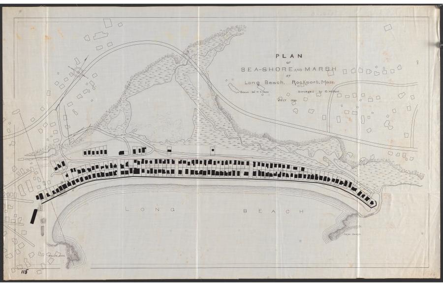
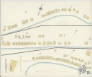
The original plan of Long Beach, with the existing 149 cottages, accessory buildings, seawall, and roads superimposed by the author. The plan shows the tidal channel, salt marsh, and beach, which was developed in the early 1900s. The seawall, which was originally constructed in 1931, stopped the dynamic beach profile from shifting during the summer and winter seasons. CW Pool.
Plan of sea-shore and marsh at Long Beach, Rockport, Mass. Map, Digital Commonwealth, 1899. Public domain. Click here to view source.
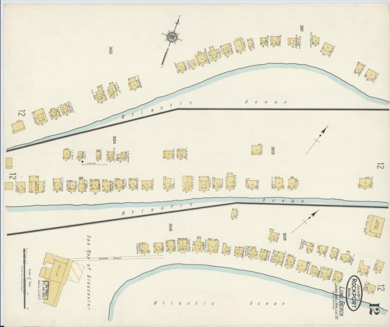
The Sanborn Fire Insurance map shows the cottages as they were originally constructed in two lines facing the Atlantic Ocean. The yellow fill of the cottages denotes that they are constructed out of wood. A 1917 Sanborn Fire Insurance
Map from Rockport, Essex County, Massachusetts. Sanborn Map Company, 1917. Library of Congress Geography and Map Division. Public domain. Click here to vierw source.
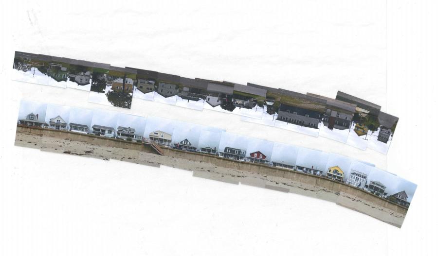
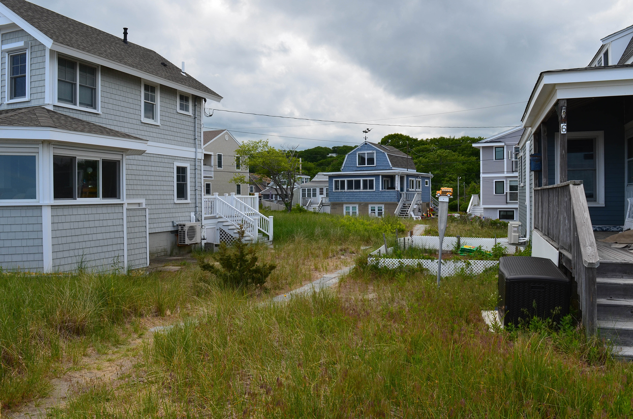
Composite collage of the structures, seawall, and road at Long Beach, Rockport. The cottages are built in two lines between the Atlantic Ocean and Saratoga marsh. The high tide line is marked by bladderwrack, driftwood, and kelp deposited by the ocean.
Collage by Kira Clingen. CC BY 4.0.
Drone transects of Long Beach describe the natural communities on Long Beach, and the physical infrastructure systems that have been constructed above, below, and through these systems. These transects are then annotated to reveal the complexities of the built environment to the general public.
Images by Kira Clingen. CC BY 4.0.

Cross-section drawings through three different places on Long Beach show how the landscape has changed over time as the cottages and the infrastructure to support them were constructed over the existing salt marsh and maritime dune system. Each section drawing is overlaid by datum lines that project future sea level rise and storm surge flooding.
Drawings by Kira Clingen. CC BY 4.0.


The town is now armed with increasingly precise aerial imagery, engineering studies, and various climate projections that make choosing a path of action difficult: 1. the seawall will be impacted by 12 inches of sea level rise, which will arrive long before the 41 inches expected by mid-century; 2. all of the cottages lie squarely within the Federal Emergency Management Agency (FEMA)’s VE (velocity) flood zone, at risk of high-velocity waves during a 100-year storm event; and 3. the cottages will be damaged from storm surge from the ocean side and the marsh in the event of a powerful nor’easter or hurricane (Town of Rockport 2020).
The town applied for emergency grants to begin repairing the Long Beach seawall in 2023, despite community debate around its vulnerability spurred by the formation of a committee within Rockport’s municipal government to “consider the Town’s options … with due regard for environmental issues, in particular rising sea levels” (Long Beach Options Committee 2022: 6).

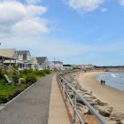
Sunny day flooding at mid-tide on Long Beach Road, the privately owned access road to the cottages. The road is one example of an impervious surface on Long Beach that limits water from percolating into the soil.
Sunny day flooding at mid-tide on Long Beach Road, the privately owned access road to the cottages. The road is one example of an impervious surface on Long Beach that limits water from percolating into the soil.
Photograph by Kira Clingen.
This work is licensed under a Creative Commons Attribution 4.0 International License.
While previous reports have studied the seawall, sediment transport, and beach erosion, the Options Committee hosted public meetings—twice monthly from June 2021 to March 2022—that increased the visibility of the climate hazards at Long Beach (Long Beach Options Committee 2022: 6; United States Army Corps of Engineers 1961; Applied Coastal Research and Engineering 2014). Local newspaper articles publicized split viewpoints on renewal or retreat from community members (Hagan 2023; Baker 2023). Ultimately, the Rockport Board of Selectmen renewed the 10-year leases between Rockport and the cottage owners until 31 December 2033 and applied for emergency grants to begin repairing portions of the seawall (Town of Rockport 2023).

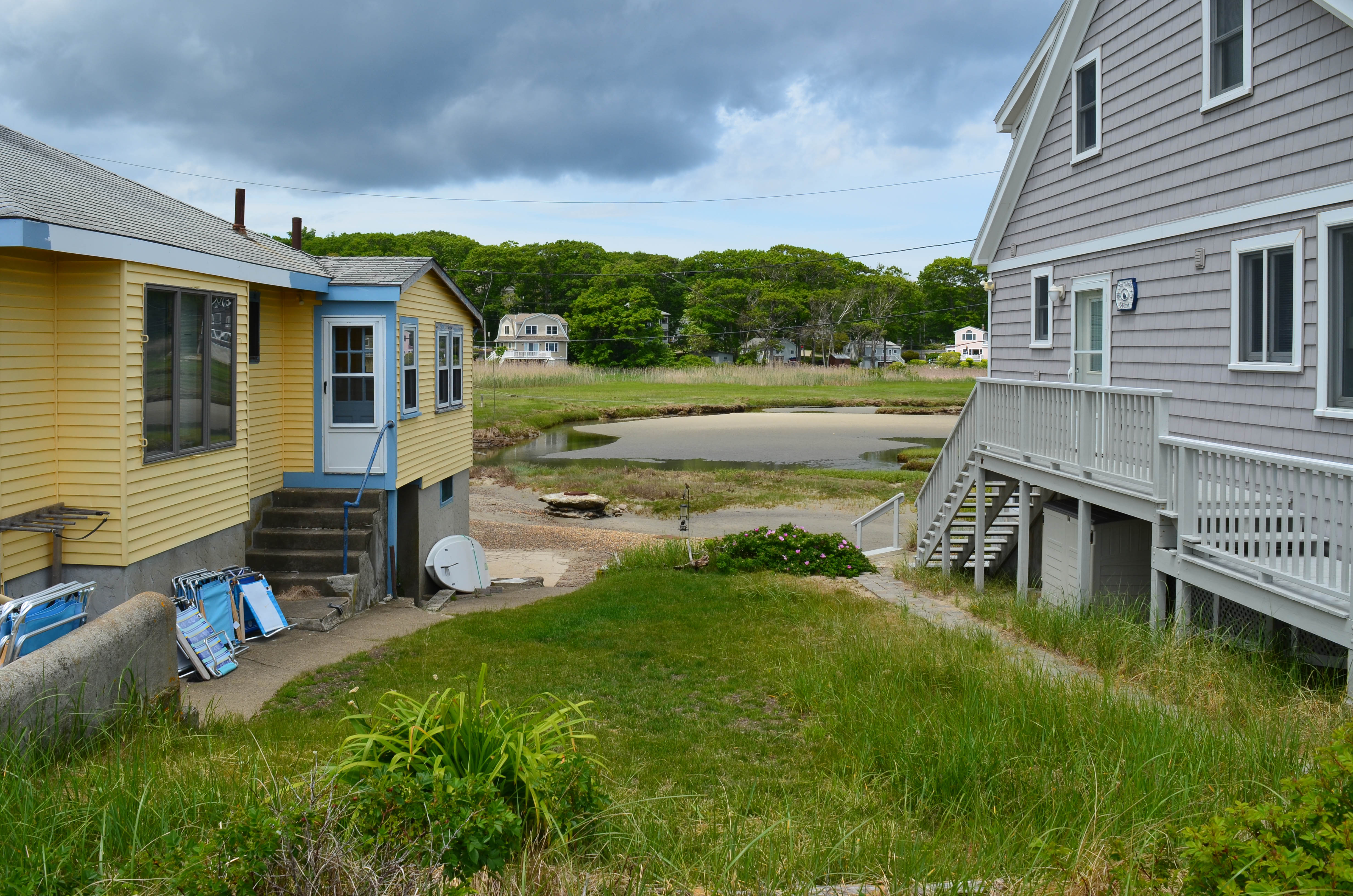
Great egrets (Ardea alba) and herring gulls (Larus argentatus) forage for small fish and crustaceans in the Saratoga marsh behind the development. Low marsh grass (Spartina alterniflora) grows along the creek while saltmarsh hay (Spartina patens) falls in licks at higher elevations in the marsh, which is flooded twice a day during high tide. A manhole, part of the sewer infrastructure system, is visible in the photograph. The manhole has been exposed due to coastal erosion.
Great egrets (Ardea alba) and herring gulls (Larus argentatus) forage for small fish and crustaceans in the Saratoga marsh behind the development. Low marsh grass (Spartina alterniflora) grows along the creek while saltmarsh hay (Spartina patens) falls in licks at higher elevations in the marsh, which is flooded twice a day during high tide. A manhole, part of the sewer infrastructure system, is visible in the photograph. The manhole has been exposed due to coastal erosion.
Photograph by Kira Clingen.
This work is licensed under a Creative Commons Attribution 4.0 International License.

Remnant coastal vegetation, including Eastern red cedar (Juniperus virginiana) and American beach grass (Ammophila breviligulata) grows between the cottages.
Remnant coastal vegetation, including Eastern red cedar (Juniperus virginiana) and American beach grass (Ammophila breviligulata) grows between the cottages.
Photograph by Kira Clingen.
This work is licensed under a Creative Commons Attribution 4.0 International License.
Long Beach is a degraded ecosystem and a cultural and social touchpoint for residents and tourists, entwined with economic systems that extend far beyond its three-quarter mile of sandy beach. In short, the question of what to do at Long Beach is a “super wicked problem” (Levin et al. 2009: 1). Addressing the complexity of these entangled ecological, social, and economic problems requires stakeholders to make a decision long before the potential worst consequences of the problem (a hurricane, litigation that bankrupts the town, or loss of life) manifest.
As in many other places, the Long Beach problem is framed around protecting privately owned structures with a publicly owned seawall. As long as this is the case, there will be an engineering solution with historical precedent on site: rebuild the wall to a higher elevation. Yet the seawall contributes to a false sense of security, encouraging sustained development and increasing the potential for loss of life and property during a storm event. The seawall has become what geographer E. Lisa F. Schipper calls an example of “maladaptation” that increases exposure to climate change impacts (Schipper 2020: 409).

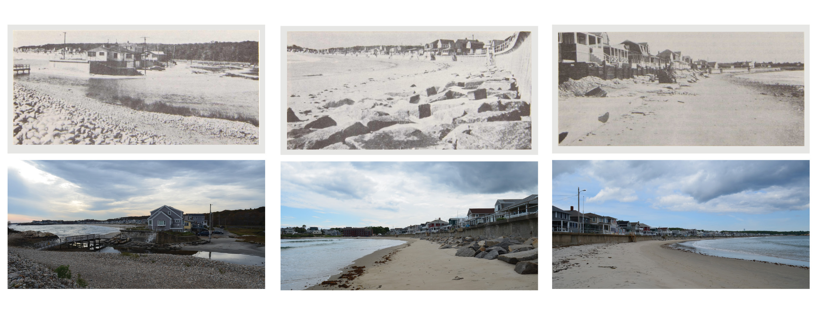
Rephotographing the same scene is used to show changes in the landscape over time. In 2024, the author rephotographed three places on Long Beach from the same vantage point that the United State Army Corps of Engineers photographed in 1960. The photographs show the persistent flooding on Long Beach, erosion of the beach, and the deterioration of the seawall.
Rephotographing the same scene is used to show changes in the landscape over time. In 2024, the author rephotographed three places on Long Beach from the same vantage point that the United State Army Corps of Engineers photographed in 1960. The photographs show the persistent flooding on Long Beach, erosion of the beach, and the deterioration of the seawall.
Top photographs: US Army Corps of Engineers. 1960. Beach Erosion Control Report on Cooperative Study of Rockport, Massachusetts, Photograph, Public Domain.
Bottom photographs by Kira Clingen, 2024.
This work is licensed under a Creative Commons Attribution 4.0 International License.
This precludes other potential futures, including one in which the settlement retreats and returns Long Beach “to nature in perpetuity” (Koslov 2016: 363). As Rosetta Elkin writes, this process only begins when “landscape is appreciated, so that retreat can be valued” (2023).
Retreat would not return Long Beach to an untouched barrier beach landscape. No matter the cause, when the cottages and seawall are gone, its beach, dune, and marsh systems will be a novel reconstruction. For Long Beach to persist into the next century, the leases need to be terminated, the structures deconstructed, the seawall crushed, and the dune restored. This represents a fundamental shift in ownership on Long Beach and, more broadly, a shift in cultural landscape practices on Cape Ann from fortified coastlines to reconstructed ecosystems.
Ultimately, the sea will reclaim Long Beach. As New England landscape historian John Stilgoe writes, “no built form endures long in the wilderness of the intertidal zone, or even on the dunes and rocks just inland from the farthest reach of the tide” (Stilgoe 1994: 2). As climate impacts arrive on Long Beach, the question is whether it will become what Elkin describes as a “portrait” either of proactive retreat or of status quo maladaptation.
Further Readings
- Applied Coastal Research and Engineering. Long Beach, Rockport, Massachusetts, Sediment Study. Rockport, MA: Town of Rockport, 2014.
- Babson, John James. History of the Town of Gloucester, Cape Ann: Including the Town of Rockport. Gloucester, MA: Procter Brothers, 1860.
- Baker, Billy. “Long Beach in Rockport is a summer paradise. It may also be a climate disaster waiting to happen.” Boston Globe. 4 August 2023. https://www.boston.com/news/the-boston-globe/2023/08/08/long-beach-in-rockport-is-a-summer-paradise-it-may-also-be-a-climate-disaster-waiting-to-happen/
- Conkling, Philip W. From Cape Cod to the Bay of Fundy: An Environmental Atlas of the Gulf of Maine. Cambridge, MA: MIT Press,1995.
- Elkin, Rosetta. Landscapes of Retreat. Berlin: Keller Verlag, 2023.
- Hagan, Stephen. “New leases negotiated for Long Beach properties.” Gloucester Daily Times. 11 December 2023. https://www.gloucestertimes.com/news/local_news/new-leases-negotiated-for-long-beach-properties/article_c9eea280-960c-11ee-a9c9-e74b3df9be1c.html
- Koslov, Liz. “The Case for Retreat.” Public Culture 28, no. 2 (2016): 359–387. doi:10.1215/08992363-3427487.
- Levin, Kelly, Benjamin Cashore, Steven Bernstein, and Graeme Auld. “Playing it forward: Path dependency, progressive incrementalism, and the ‘Super Wicked’ problem of global climate change.” IOP Conference Series: Earth and Environmental Science 6 (2009): 1–7. doi:10.1088/1755-1307/6/50/502002.
- Long Beach Options Committee. Final Report for Rockport Town Meeting. Rockport, MA: Long Beach Options Committee, 2022.
- United States Army Corps of Engineers. Beach Erosion Control Report on Cooperative Study of Rockport, Massachusetts. Washington, D.C.: US Army Corps of Engineers, 1961.
- Schipper, E. Lisa F. “Maladaptation: When Adaptation to Climate Change Goes Very Wrong.” One Earth 3, no. 4 (2020): 409–14. doi:10.1016/j.oneear.2020.09.014.
- Stilgoe, John. Alongshore. New Haven: Yale University Press, 1994.
- Town of Rockport. Rockport Hazard Mitigation Plan 2020 Update. Rockport, MA: Town of Rockport, 2020.
- Town of Rockport. Long Beach Lease Agreement and Memo. Rockport, MA: Town of Rockport, 2023.
How to cite
Clingen, Kira. “Dunes, Development, and Delay: Climate Change Comes to Long Beach.” Environment & Society Portal, Arcadia (Spring 2025), no. 3. Rachel Carson Center for Environment and Society. https://www.environmentandsociety.org/node/9929.
ISSN 2199-3408
Environment & Society Portal, Arcadia
This work is licensed under a Creative Commons Attribution 4.0 International License.
2025 Kira Clingen
This refers only to the text and does not include any image rights.
Please click on an image to view its individual rights status.


