Copyright information
“The City’s Currents: A History of Water in 20th-Century Bogotá” was created by Stefania Gallini, Laura Felacio, Angélica Agredo, and Stephanie Garcés (2014) under a Creative Commons Attribution-NonCommercial-ShareAlike 4.0 International license.
This refers only to the text and does not include any image rights. Please click on an image to view its individual rights status.
Introduction
Introduction
The exhibition logo has been created by Tangrama (Mónica Páez Pérez and María José Castillo Ortega) and edited by the Environment and Society Portal in 2014.
 This work is licensed under a Creative Commons Attribution-NonCommercial-ShareAlike 3.0 Unported License.

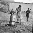
Water supply and consumption
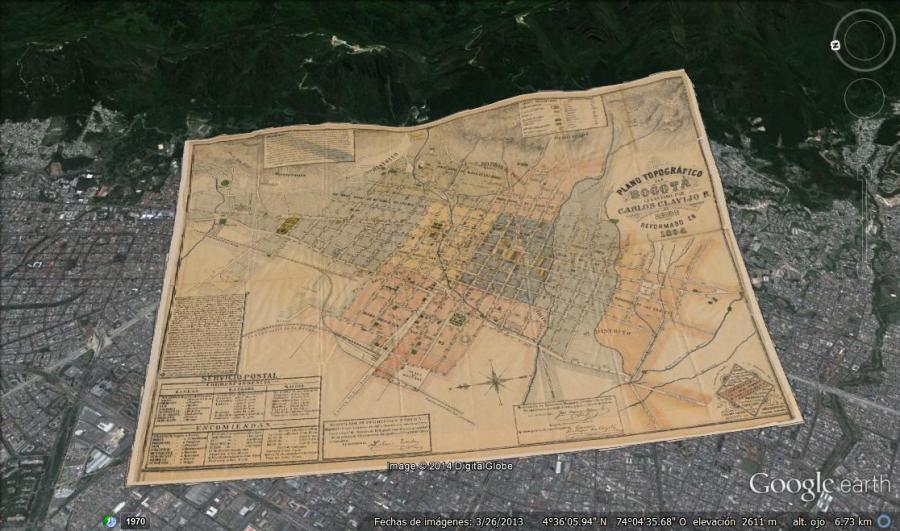
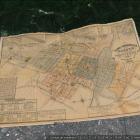
Map made by Carlos Clavijo in 1891 and revised by Rafael Álvarez Salas in 1894. By this time, the city of Bogotá was divided into five police quarters and eight ecclesiastical districts called parroquias, which are shaded in different colors on the map. The map identifies the main squares and parks of the city, the government buildings, the educational and cultural institutions, and the Catholic churches, as well as a number of banks, factories, brickworks, hotels, and restaurants. The rivers and streams that descend from the mountains of Monserrate and Guadalupe run through the city, shaping the streets and blocks. Near the San Bruno Rivulet, tributary of the San Francisco River, are the water storage tanks of the Egipto neighborhood, used since the late nineteenth century to store water for the municipal aqueduct service. Northeast of the city, in the foothills of Monserrate, are the Baños de la Tuerta Chepa, an example of what once were public bathhouses.
Map made by Carlos Clavijo in 1891 and revised by Rafael Álvarez Salas in 1894. By this time, the city of Bogotá was divided into five police quarters and eight ecclesiastical districts called parroquias, which are shaded in different colors on the map. The map identifies the main squares and parks of the city, the government buildings, the educational and cultural institutions, and the Catholic churches, as well as a number of banks, factories, brickworks, hotels, and restaurants. The rivers and streams that descend from the mountains of Monserrate and Guadalupe run through the city, shaping the streets and blocks. Near the San Bruno Rivulet, tributary of the San Francisco River, are the water storage tanks of the Egipto neighborhood, used since the late nineteenth century to store water for the municipal aqueduct service. Northeast of the city, in the foothills of Monserrate, are the Baños de la Tuerta Chepa, an example of what once were public bathhouses.
Historical map: Public domain. Courtesy of Biblioteca Nacional de Colombia.
Overlap of the historical map over satellite imagery from Google Earth: Creative Commons Attribution-NonCommercial-ShareAlike 3.0 Unported License. 2014. Biblioteca Nacional de Colombia.
 This work is licensed under a Creative Commons Public Domain Mark 1.0 License.

Female laundry workers
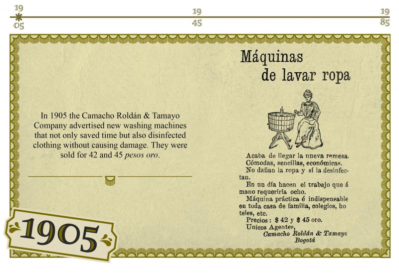
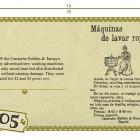
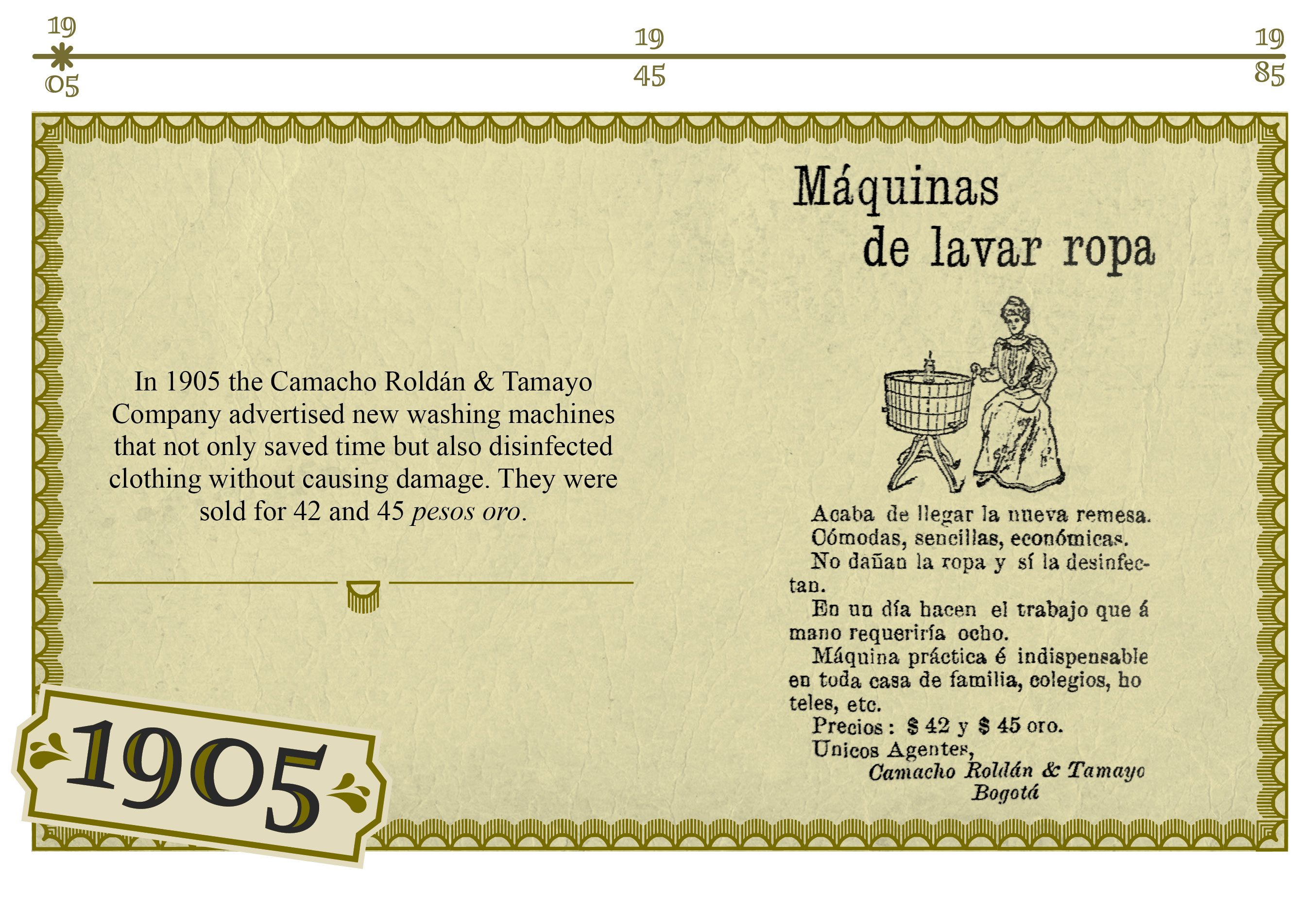
“Máquinas de lavar ropa: Camacho Roldán & Tamayo”, El Nuevo Tiempo, January 20, 1905, 1.
“Máquinas de lavar ropa: Camacho Roldán & Tamayo”, El Nuevo Tiempo, January 20, 1905, 1.
Advertisement: Public domain.
Infographic: “CC-BY-NC-SA 3.0 Unported License.” Mónica Páez Pérez and María José Castillo Ortega. Tangrama, 2013.

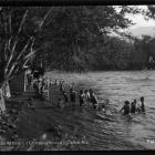
Bathrooms and personal hygiene
Bathrooms and personal hygiene
All rights reserved. Biblioteca Luis Ángel Arango. Banco de la República de Colombia. Courtesy of Mario Cuéllar Bobadilla.
The copyright holder reserves, or holds for their own use, all the rights provided by copyright law, such as distribution, performance, and creation of derivative works.
Further reading
Further reading
This work is in the public domain.
This work is licensed under a Creative Commons Public Domain Mark 1.0 License.

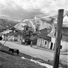
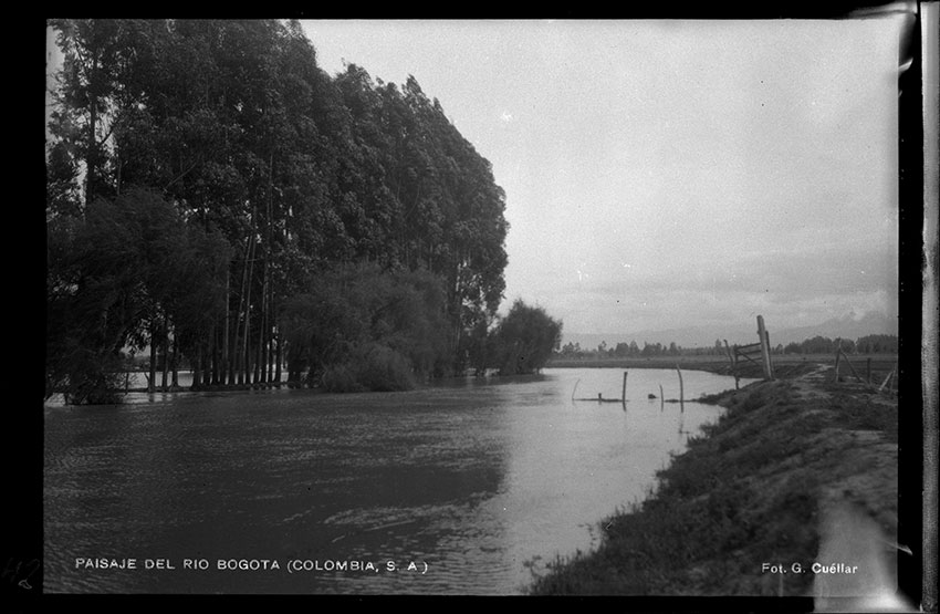
Gumersindo Cuéllar Jiménez, Paisaje del río Bogotá (Colombia, S. A.)
Gumersindo Cuéllar Jiménez, Paisaje del río Bogotá (Colombia, S. A.)
Floods caused by waterways such as the Bogotá and Tunjuelo rivers happen almost every rainy season. This image shows the effects of regular overflows of the Bogotá River on farms located in the Bogotá Savanna, west of the city.
All rights reserved. Biblioteca Luis Ángel Arango. Banco de la República de Colombia. Courtesy of Mario Cuéllar Bobadilla.
The copyright holder reserves, or holds for their own use, all the rights provided by copyright law, such as distribution, performance, and creation of derivative works.

Acknowledgments
Acknowledgments
Cutting from an image by pjenz.
View soure.
This work is licensed under a Creative Commons Attribution-NonCommercial-ShareAlike 3.0 Unported License.
For more information on the historical photographs and maps, please go to the respective chapters.
The City's Currents: A History of Water in 20th-Century Bogotá
This exhibition explores the role of water in the struggle of Colombia’s capital to become a modern city. For Bogotá, complying with the standards of sanitary reformers and the governing elite was a social, technological, and environmental control endeavor. The exhibition examines everyday and gendered experiences of water, such as washing clothes or bathing, as well as urban infrastructural interventions including the domestication of rivers for water supply and wastewater disposal systems.
Stefania Gallini, Laura Felacio, Angélica Agredo, and Stephanie GarcésAbout the author


