geography

"Mapping Scenario Narratives: A Technique to Enhance Landscape-scale Biodiversity Planning"

Carter et al. translate key themes from scenario narratives into spatial representations using Geographic Information Systems (GIS). They apply this technique to a Tasmanian case study exploring future scenarios for biodiversity in a predominantly privately-owned agricultural landscape, enabling land managers to explore outcomes from potential interventions and identify strategies that might mitigate the impact of future issues of environmental concern.

Bitumen Exploration and the Southern Re-Inscription of Northeastern Alberta: 1875–1967

Longley traces how geographic and cartographic knowledge of the Athabasca region, Alberta, Canada, colonized the region in the southern imagination long before the oil sands industry began extraction there. The practices of exploration, surveying, and documentation mapped the Athabasca region in terms of its rich bitumen deposits, obscuring the histories of Indigenous people. The south gained political and economic control of the region, although this process is incomplete and contested.

Cartografía histórica

Cartografía histórica

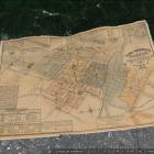
Los mapas son representaciones más políticas que objetivas sobre un lugar. Al seleccionar y codificar algunas piezas de información, mientras se silencian otras, los mapas funcionan como discursos políticos y son usados como “órdenes de marcha” para construir geografías.

Historical cartography

Historical cartography

Maps are political rather than objective representations of a place. By selecting some pieces of information and codifying them, while silencing others, maps work as political discourses and are used as “marching orders” of geographies to be built.