In the late nineteenth and early twentieth centuries, the construction of drainage tunnels to dewater the lead mines of Halkyn Mountain in north-east Wales was controversial. Local concerns were expressed over the disruption caused above and below ground, while geologists and engineers acted as expert witnesses in Parliamentary hearings, debating the nature of subterranean formations and the direction of underground water flow.
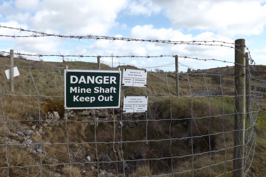
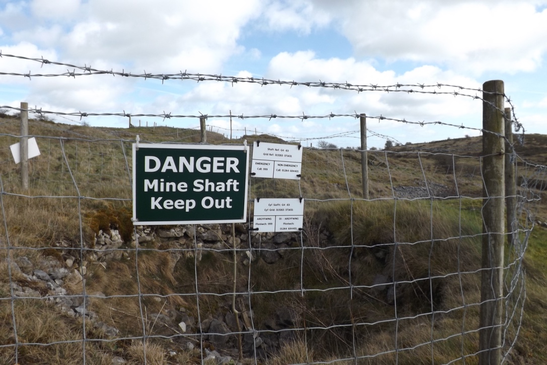
Lead mining had a dramatic effect on Halkyn Mountain. Today, the landscape is filled with evidence of disused shafts and other mine workings.
Lead mining had a dramatic effect on Halkyn Mountain. Today, the landscape is filled with evidence of disused shafts and other mine workings.
Photograph by Mark Nuttall
 This work is licensed under a Creative Commons Attribution 4.0 International License.
Halkyn Mountain (Mynydd Helygain, in Welsh) is an upland common on a spine of carboniferous limestone in the county of Flintshire. Although lead had been extracted there since Roman times, it developed into one of Britain’s major lead mining areas from the late eighteenth to the early twentieth centuries as demand grew for lead in manufacturing, building, and infrastructure. As miners went deeper in search of rich veins of ore, however, water levels rose. Mine owners constructed passages known as adits and wider tunnels to drain the mines, yet flooding remained a significant problem. By the 1870s a number of Halkyn mines had closed, partly due to poor drainage and competition from imported ore, so grander tunnel projects were proposed. In 1875 an Act of Parliament empowered the Halkyn District Mines Drainage Company to develop the Halkyn Deep Level tunnel system, while another Act in 1896 empowered the Holywell-Halkyn Mining and Tunnel Company to drive the Milwr Tunnel, or Sea-Level Tunnel. This was begun in 1897, with the portal at sea level near the small town of Bagillt on the bank of the Dee Estuary.

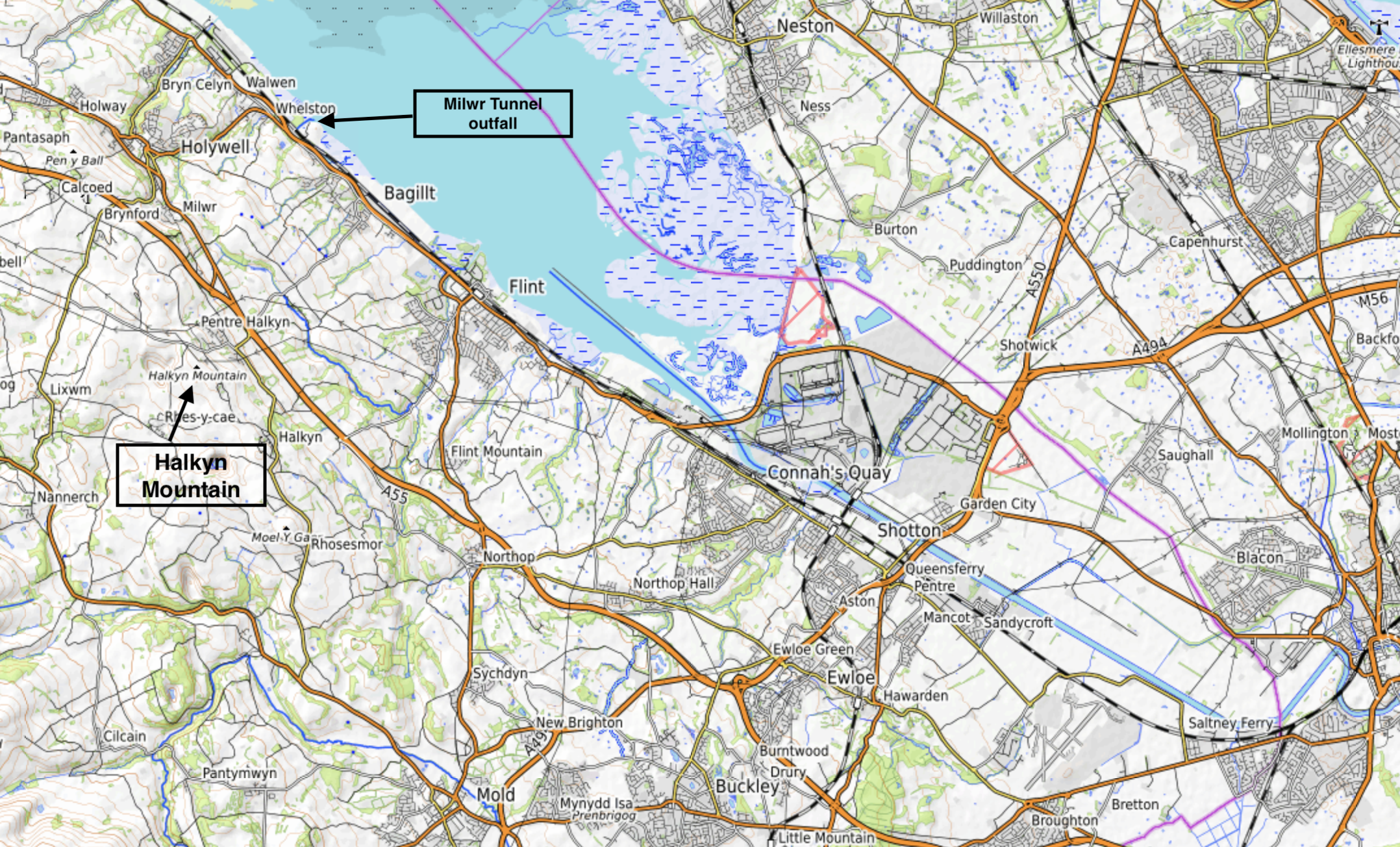
Map of Flintshire and the northern part of the Welsh-English borderlands showing Halkyn Mountain and the Milwr Tunnel outfall (author’s annotations).
Map of Flintshire and the northern part of the Welsh-English borderlands showing Halkyn Mountain and the Milwr Tunnel outfall (author’s annotations).
Map courtesy of OpenTopoMap https://opentopomap.org/#map=12/53.2279/-3.0600 Map data: © OpenStreetMap contributors, SRTM | map style: © OpenTopoMap. This map has been modified.
 This work is licensed under a Creative Commons Attribution-ShareAlike 3.0 Unported License.
The Milwr Tunnel was promoted as a triumph of engineering by the company’s directors. Yet local knowledge suggested that the water drained by the Milwr Tunnel flowed from the south and had the same underground source as that for St. Winifrede’s Well, a shrine famed for its curative powers at the town of Holywell just to the north of Halkyn Mountain, and the Holywell Stream, which was vital for local water supplies and for agriculture and industry, such as flannel mills and copper smelting. Petitions against the tunnel were signed and newspapers in North Wales reported that local landowners, parish councilors, businesses, and farmers were worried that the tunnel would divert the water and affect the stream.
In 1904, the Milwr and District Mines Drainage Bill, which proposed a southward expansion of the Milwr Tunnel, was debated in the House of Commons. Some MPs supported those who were anxious about the effects on Holywell’s water supply, St. Winifrede’s Well, and local industries. Evidence from ground water management engineers and data showing readings of low water levels at the well since construction began in 1897 were cited. Supporters of the Bill pointed out that the area covered by the drainage scheme was “acknowledged by all experts to be very rich in minerals,” argued that other tunnels and adits in the area had not caused any harm, and disputed that Holywell derived its entire water supply from any underground stream at risk of diversion by the tunnel. The hearings were filled with lively discussion about subsurface geology, the materiality of limestone, and the science of underground water flow. Geologists—including William Boyd Dawkins, who was professor of geology at Owens College, Manchester—appeared as expert witnesses and presented theories about the source of the watershed that supplied the well and the location of major veins such as the Caleb Bell Cross Course. Dawkins warned that the tunnel scheme would likely deplete the well, while other geologists such as William Whitaker and Richard Hill Tiddeman argued the well had a different water source originating from the west. The matter of water flow could not be settled, but the supporting economic arguments for tunnel expansion and mining were strong, and the Bill passed into law.
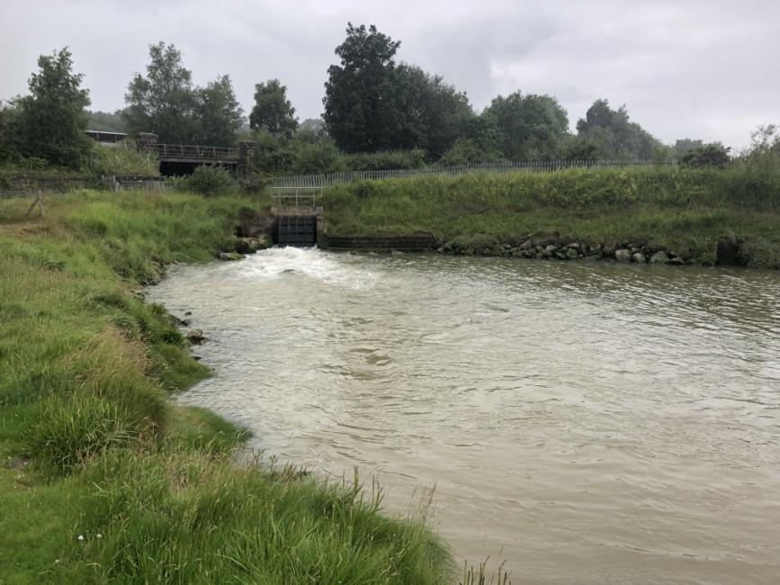
The outfall channel of the Milwr Tunnel near Bagillt on the Dee Estuary is known locally as “The Holy.”
The outfall channel of the Milwr Tunnel near Bagillt on the Dee Estuary is known locally as “The Holy.”
Photograph by Mark Nuttall
This work is licensed under a Creative Commons Attribution 4.0 International License.
In July 1913, the flow of water to St. Winifrede’s Well was central to another parliamentary hearing for a Bill that proposed further southward expansion of the Milwr Tunnel. Geologists were again brought in as expert witnesses. Those in support of the tunnel company argued that the watershed lay to the west and northwest, where no tunneling would take place, while those giving evidence in support of the Bill’s opponents argued that the water feeding the well and the Holywell Stream flowed from the south, and that tunneling would cut into and divert the source. The former view seemed to convince Parliament. The Bill passed into law and tunnel expansion commenced. In the first week of January 1917, St. Winifrede’s Well ran dry after the Caleb Bell Cross Course was cut into, confirming that some or much of its water flow originated to the south. The North Wales Chronicle reported that the water’s “startling disappearance” proved who was right in “the battle of geological experts in the Committee Rooms of the House of Commons.” Although flow eventually resumed to the well, it was not enough to provide water for local industry elsewhere along the Holywell Stream, so a level was driven from an abandoned coal mine shaft to replenish it.
Work on the Milwr Tunnel continued intermittently until 1957, when it extended for ten miles from the portal. By this time, however, lead mining was declining. The Milwr Tunnel was maintained because it had become an important water supply for nearby textile mills and other industries. The last lead mine on Halkyn Mountain closed in 1987, but each day some 23,000,000 gallons of water empty into the Dee Estuary from the tunnel’s outfall.
How to cite
Nuttall, Mark. “‘The battle of geological experts’: Water Flow and Tunneling within a Welsh Mountain.” Environment & Society Portal, Arcadia (Spring 2021), no. 14. Rachel Carson Center for Environment and Society. doi:10.5282/rcc/9272.
ISSN 2199-3408
Environment & Society Portal, Arcadia
This work is licensed under a Creative Commons Attribution 4.0 International License.
2021 Mark Nuttall
This refers only to the text and does not include any image rights.
Please click on an image to view its individual rights status.
- Coyle, Geoff. The Riches Beneath Our Feet: How Mining Shaped Britain. Oxford: Oxford University Press, 2010.
- Ebbs, Chris. The Milwr Tunnel: Bagillt to Loggerheads. Cris Ebbs: Llanarmon-yn-ial, 2008.
- Jones, Nigel, Mark Walters, and Pat Frost. Mountains and Orefields: Metal Mining Landscapes of Mid and North-East Wales. CBA Research Report 142. York: Council for British Archaeology, 2004.
- Nuttall, Mark. “Lead Mining, Conservation and Heritage: Shaping a Mountain in Northeast Wales.” Humanities 9, no.3: 70 (2020). doi:10.3390/h9030070.
- Williams, Christopher J., and R. Alan Williams. “Rediscovering the Lead and Zinc Production of North-East Wales.” Welsh Mines and Mining 2 (2012): 13–31.


