Natural Laboratories
Being a unique location worldwide is the first attribute that defines a natural laboratory. However, to become such, it also requires the vision of researchers and public policies that allow it to be implemented. This confluence of biophysical, cultural, and political attributes has come together to create the natural laboratories of Cape Horn in the subantarctic Magellanic ecoregion and in the Atacama Desert in Chile. In its biophysical dimension, the Cape Horn Biosphere Reserve (CHBR) has no biogeographic replica at a planetary level, and provides a baseline from which it is possible to investigate some ecosystems under preindustrial conditions to allow a better understanding of climate change. In its cultural dimension, researchers have generated a methodological approach called “field environmental philosophy” for integrating the natural sciences along with the humanities, the arts, and ethics into biocultural conservation, education, and research. In Atacama, the place with the clearest skies on the planet, the world’s largest platform for the development of astronomical observations has been established. This section guides readers to learn about the research platforms at these two unique natural laboratories.
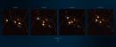
Switch between the microcosm and macrocosm perspectives by clicking on the circles below.
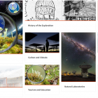
The original virtual exhibition includes the option to switch between the microcosm and macrocosm within the individual chapters (see screenshot below).
Here we present the subchapters one after the other.
The Cape Horn Research, Education, and Conservation Platform

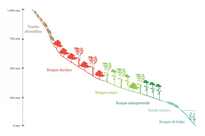
Figure 1. Detail of altitudinal gradient and sampling sites through the Róbalo River watershed protected by the Omora Park. To empirically investigate the impact of climate change on subantarctic insects and plants, places with different temperatures and climatic conditions are selected as long-term study sites along the altitudinal gradient. Figure created by Silvia Lazzarino, n.d.
Figure 1. Detail of altitudinal gradient and sampling sites through the Róbalo River watershed protected by the Omora Park. To empirically investigate the impact of climate change on subantarctic insects and plants, places with different temperatures and climatic conditions are selected as long-term study sites along the altitudinal gradient. Figure created by Silvia Lazzarino, n.d.
© Fundación Omora. Used by permission.
The copyright holder reserves, or holds for their own use, all the rights provided by copyright law, such as distribution, performance, and creation of derivative works.
In 2000, the Omora Ethnobotanical Park, Navarino Island, was created as a natural laboratory, an outdoor classroom, and a long-term ecological research (LTER) site for the Cape Horn Biosphere Reserve (CHBR). It also serves as a “sentinel for climate change” because Omora Park protects a river basin that includes habitat types characteristic of the CHBR in an altitudinal gradient with a thermal decrease analogous to that which occurs with increases in latitude (Figure 1). This makes it an ideal site for studies on climate change and its impact on biota and subantarctic ecosystems.
Among the functions of biosphere reserves is the support scientific research, education, training, and monitoring. In the CHBR, created in 2005, this function has been fulfilled with the creation of the Omora Ethnobotanical Park in 2000, and its implementation in 2008 as a cofounder site of the Chilean Long-Term Socio-Ecological Research Network (LTSER). In 2016, this network was strengthened with the addition of the new Cape Horn Long-Term Socio-Ecological Research Network (LTER-Cape Horn). The latter includes the Omora Ethnobotanical Park, and three new sites added to the monitoring of the subantarctic Magellanic ecoregion (Figure 2).
In 2015, UNESCO approved the Report of the First Periodic Review of the CHBR that proposed the protection of the Diego Ramírez archipelago and the creation of the Diego Ramírez Islands–Drake Passage Marine Park (DRMP). The promulgation of this new park was finally achieved on 2 February 2018, and it was officially decreed by the Chilean government on 21 January 2019 (Official Gazette 2019). In this context, the new LTER-Cape Horn network has been given relevance on a local and global scale. At the local scale, it covers a representative environmental heterogeneity of the great diversity of landscapes and terrestrial, freshwater, and marine ecosystems that characterize the subantarctic Magellanic ecoregion. On a global scale, the terrestrial ecosystems of the LTER-Cape Horn network stand out for two main reasons: (1) these subantarctic ecosystems lack a geographical replicate in other continents of the Southern Hemisphere, and (2) high-latitude ecosystems are especially sensitive to global climate change. Thus, the LTER-Cape Horn network helps to overcome critical geographical gaps in the implementation of the International Network for Long-Term Ecological Research Network (ILTER). The implementation of the LTER-Cape Horn network is based on a close collaboration with various public institutions: the Ministry of National Assets, the Ministry of the Environment, the Undersecretariat of Fisheries and Aquaculture of the Ministry of Economy, Development and Tourism, the National Forestry Service, the General Water Directorate of the Ministry of Public Works, the Chilean Navy, the Chilean national law enforcement police (Carabineros de Chile), the municipality of Cape Horn, the provincial government of Chilean Antarctica, and the regional government of Magallanes and Chilean Antarctica. In the future, the LTER-Cape Horn network and the Cape Horn Center aim to strengthen the participation of the local community, especially the Yaghan Indigenous Community of Bahía Mejillones, artisanal fisheries, tour operators, and the educational community, including private actors. Located at the “southern summit” of the Americas, Puerto Williams, capital of the Chilean Antarctic Province, emerges as a global hub for transdisciplinary subantarctic research.

Figure 2. The LTER-Cape Horn Network with its four main sites for long-term ecological studies, from south to north: (1) Gonzalo Island (56°31’ south, 68°43’ west), at the southern end of the Diego Ramírez Archipelago, with subantarctic vegetation dominated by grasses and cryptogams, devoid of woody species; (2) Horn Island (55°58’ south, 67°13’ west), at the southern end of the Cape Horn Archipelago, hosting the southernmost forest ecosystems on the planet, which are dominated by the evergreen beech (Nothofagus betuloides); (3) Omora Park (54°57’ south, 67°40’ west), Navarino Island, an ideal site for studies on climate change and its impact on biota and subantarctic ecosystems, since it protects a watershed that includes a representative mosaic of characteristic habitats of the CHBR in an altitudinal gradient with a thermal decrease analogous to that which occurs with increases in latitude; and (4) Caleta 2 de Mayo Site (54°52’ south, 68°41’ west), Yendegaia Bay, in an ecotonal zone between evergreen and deciduous forests (product of the local climate gradient), at a site that will be central to future connectivity between continental Chile, Tierra del Fuego, Navarino Island, and the CHBR. Note in the central box that the Diego Ramírez Islands are near the edge of the continental shelf. In each of the side boxes, yellow dots indicate the location of monitoring stations in terrestrial, freshwater, and coastal-marine ecosystems. Figure taken from Rozzi et al. (2020).
Figure 2. The LTER-Cape Horn Network with its four main sites for long-term ecological studies, from south to north: (1) Gonzalo Island (56°31’ south, 68°43’ west), at the southern end of the Diego Ramírez Archipelago, with subantarctic vegetation dominated by grasses and cryptogams, devoid of woody species; (2) Horn Island (55°58’ south, 67°13’ west), at the southern end of the Cape Horn Archipelago, hosting the southernmost forest ecosystems on the planet, which are dominated by the evergreen beech (Nothofagus betuloides); (3) Omora Park (54°57’ south, 67°40’ west), Navarino Island, an ideal site for studies on climate change and its impact on biota and subantarctic ecosystems, since it protects a watershed that includes a representative mosaic of characteristic habitats of the CHBR in an altitudinal gradient with a thermal decrease analogous to that which occurs with increases in latitude; and (4) Caleta 2 de Mayo Site (54°52’ south, 68°41’ west), Yendegaia Bay, in an ecotonal zone between evergreen and deciduous forests (product of the local climate gradient), at a site that will be central to future connectivity between continental Chile, Tierra del Fuego, Navarino Island, and the CHBR. Note in the central box that the Diego Ramírez Islands are near the edge of the continental shelf. In each of the side boxes, yellow dots indicate the location of monitoring stations in terrestrial, freshwater, and coastal-marine ecosystems. Figure taken from Rozzi et al. (2020).
© Fundación Omora. Used by permission.
The copyright holder reserves, or holds for their own use, all the rights provided by copyright law, such as distribution, performance, and creation of derivative works.
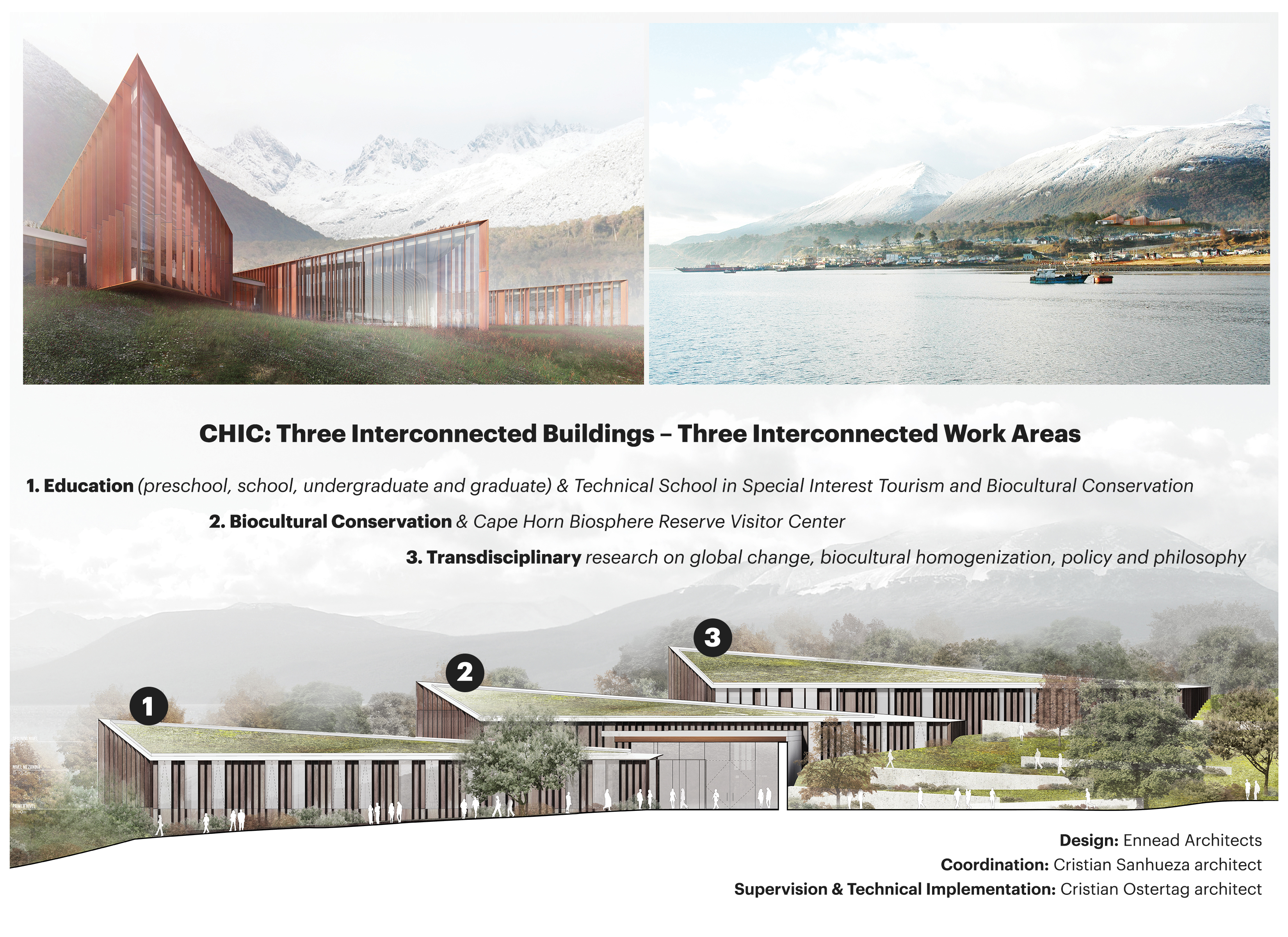
Finally, in 2022 the Cape Horn International Center (CHIC) was inaugurated in Puerto Williams. The building was funded by the regional government of Magallanes, Chile. Built on a 2.2 hectare site in the city of Puerto Williams, the center‘s size is 2,581 square meters, and it has LEED (Leadership in Energy and Environmental Design) environmental certification. It will host the University of Magallanes and the Cape Horn International Center (funded by the Chilean Agency for Research and Development [ANID], part of the Ministry of Science, Technology, Knowledge and Innovation), and it is organized in three modules: (1) Technical and Higher Education, (2) Sustainable Tourism and Biocultural Conservation, and (3) Transdisciplinary Research (Figure 3).
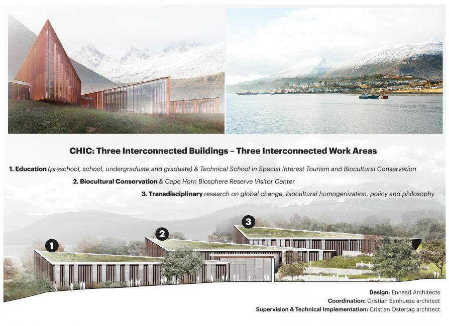
Figure 3. Digital models of the Cape Horn International Center (CHIC) building in Puerto Williams, Cape Horn Biosphere Reserve, Chile. Top left, general view from the Beagle Channel. Top right, southeast view of the CHIC building fronts. Below, placement of CHIC’s three modules in the final location and their objectives. N.d.
Figure 3. Digital models of the Cape Horn International Center (CHIC) building in Puerto Williams, Cape Horn Biosphere Reserve, Chile. Top left, general view from the Beagle Channel. Top right, southeast view of the CHIC building fronts. Below, placement of CHIC’s three modules in the final location and their objectives. N.d.
© Fundación Omora. Used by permission.
The copyright holder reserves, or holds for their own use, all the rights provided by copyright law, such as distribution, performance, and creation of derivative works.
Collaboration with regional, national, and international actors will allow the LTER-Cape Horn network and CHIC (Figure 4) to: (i) provide critical data, which will open up new opportunities for monitoring climate change and its impact on biodiversity and ecosystems in subantarctic latitudes; (ii) consolidate long-term monitoring, which is an essential component to effectively design mitigation and adaptation actions; (iii) strengthen a local sustainable development model that, in association with the CHBR, contributes from the south of the world to a biocultural conservation model that meets the needs of socio-economic well-being and environmental sustainability at multiple regional and planetary scales.

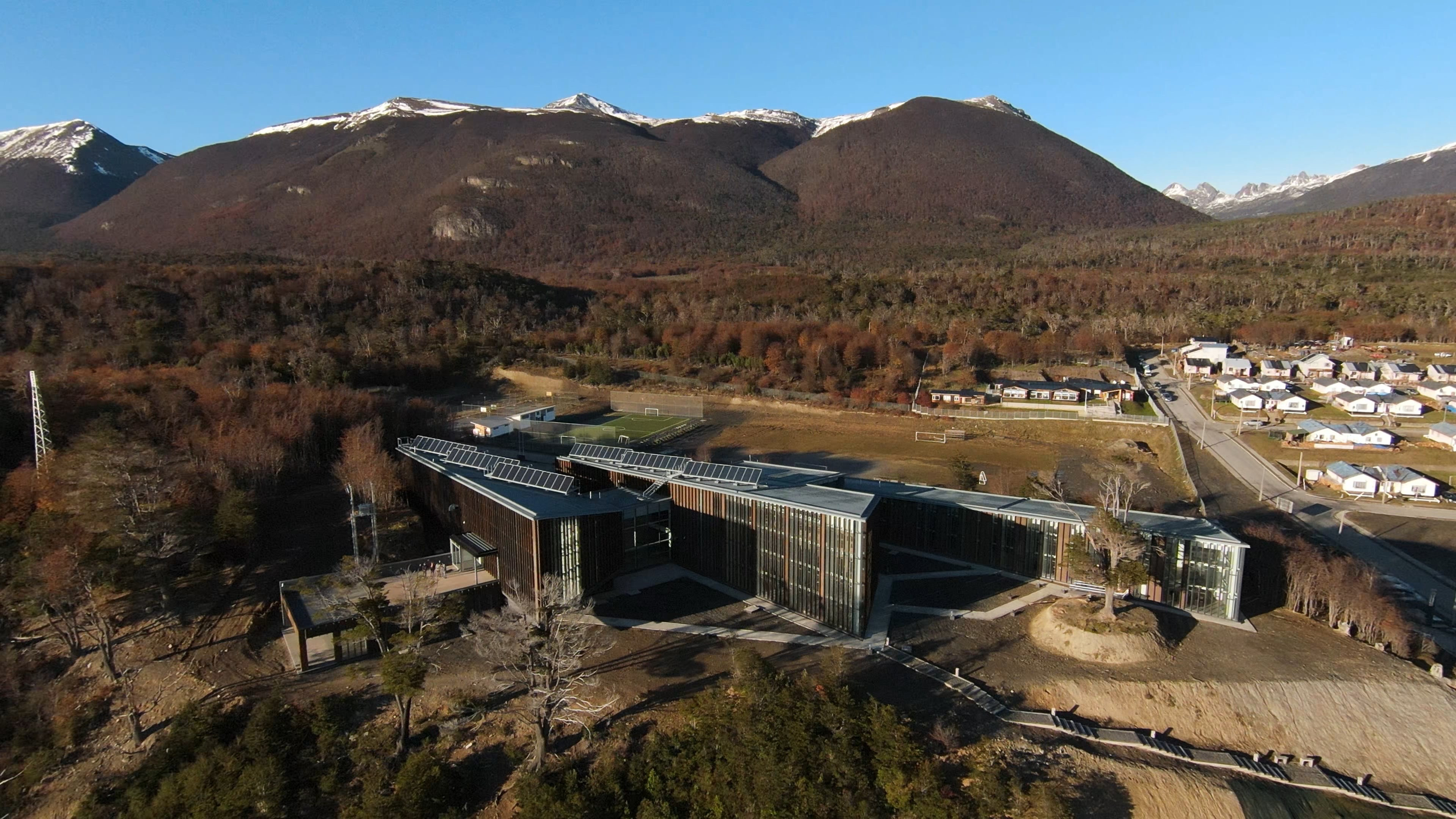
Figure 4. Photograph of the Cape Horn International Center (CHIC) building in Puerto Williams, on Navarino Island, Chile. Photograph by Camilo Quidel, May 2022.
Figure 4. Photograph of the Cape Horn International Center (CHIC) building in Puerto Williams, on Navarino Island, Chile. Photograph by Camilo Quidel, May 2022.
© Fundación Omora. Used by permission.
The copyright holder reserves, or holds for their own use, all the rights provided by copyright law, such as distribution, performance, and creation of derivative works.

The Skies as a Natural Laboratory
We could define a natural laboratory as a territory with unique natural characteristics that provides comparative advantages for the development of science and technology of high impact worldwide. In this definition, the word “territory” makes explicit reference to the importance of the place where the natural laboratory is located and its ecosystem, which, of course, includes the human and nonhuman beings who inhabit it.

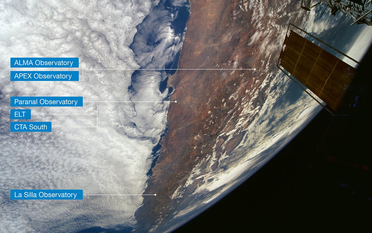
This view of northern Chile, as seen from the NASA Space Shuttle during a servicing mission to the Hubble Space Telescope (partly visible to the right), shows the Atacama Desert, where ESO’s observatories are located. Northernmost is the Atacama Large Millimeter/submillimeter Array (ALMA) and the Atacama Pathfinder Experiment (APEX), two international observatories of which ESO is a partner. ESO’s Paranal Observatory, home to ESO’s Very Large Telescope and where the future ESO Extremely Large Telescope (ELT) and the south site of the Cherenkov Telescope Array (CTA) will be located, are a few hundred kilometers southwest of ALMA and APEX. The La Silla Observatory, ESO’s first observatory, is even further south. Few clouds are seen in this extremely dry area, due to the influence of the cold Humboldt Current along the Chilean Pacific coast (left) and the high Andes mountains (right) that act as a barrier. Background photo courtesy of ESA astronaut Claude Nicollier, n.d.
This view of northern Chile, as seen from the NASA Space Shuttle during a servicing mission to the Hubble Space Telescope (partly visible to the right), shows the Atacama Desert, where ESO’s observatories are located. Northernmost is the Atacama Large Millimeter/submillimeter Array (ALMA) and the Atacama Pathfinder Experiment (APEX), two international observatories of which ESO is a partner. ESO’s Paranal Observatory, home to ESO’s Very Large Telescope and where the future ESO Extremely Large Telescope (ELT) and the south site of the Cherenkov Telescope Array (CTA) will be located, are a few hundred kilometers southwest of ALMA and APEX. The La Silla Observatory, ESO’s first observatory, is even further south. Few clouds are seen in this extremely dry area, due to the influence of the cold Humboldt Current along the Chilean Pacific coast (left) and the high Andes mountains (right) that act as a barrier. Background photo courtesy of ESA astronaut Claude Nicollier, n.d.
Courtesy of ESO/Modified from original by Claude Nicollier.
Click here to view source.
 This work is licensed under a Creative Commons Attribution 4.0 International License.
Chile is a privileged country. It has unique geographical conditions due to its great extension in latitude, combining factors such as climate, the height of the Andes mountains, and its coast of more than four thousand kilometers, accompanied in all its extension by the Humboldt Current and the sea that reaches great depths, particularly in the Atacama Trench. All this creates multiple geographical spaces or, rather, territories that can be qualified as natural laboratories, with the potential to be scenarios for the development of local science and research but addressing issues of global interest.
Among the natural laboratories that can be identified in Chile are: the sea, the northern skies, the desert, the mountains (and their minerals), and the subantarctic territory. Of these, it could be argued that the northern skies are one of the most advanced in terms of attracting great infrastructure and contributing to the scientific community. Since the arrival of the first observatories, almost 60 years ago, this natural laboratory has attracted international investment valued at more than eight billion dollars for the construction of the largest and most powerful telescopes in the world. The arrival of the observatories was also accompanied by a visionary public policy, which gives a percentage of the telescopes’ observation time to researchers associated with Chilean institutions. This policy has fulfilled its purpose and managed to establish, over the years, a scientific community that grew from a couple of dozen people in 1990 to more than a thousand today, including students, professors, and postdocs in more than two dozen universities throughout the country (data from the census made by Sociedad Chilena de Astronomía [SOCHIAS] in 2021). This community, now mature, is also involved in the construction of part of the instrumentation for the observatories and is integrated into the international collaborations that have made discoveries of great importance in recent years. In addition, it can perform in leadership positions within the international scientific governance, both in the managing of the observatories and representing international institutions in Chile, thus carrying out the formal and diplomatic relationship with the host country, an important part of what we define as “astropolitics.”
The original virtual exhibition includes an interactive gallery of images. View the images on the following pages.
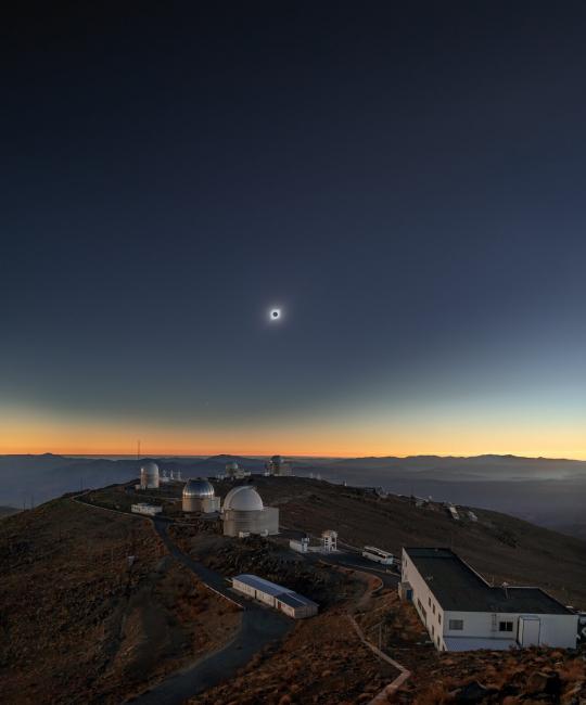
On 2 July 2019, ESO’s La Silla Observatory was host to a rare astronomical event, a total solar eclipse. Inaugurated in 1969, La Silla Observatory led ESO to the front line of astronomical science. The 50th anniversary celebrated La Silla’s continued contribution to science, and coincided fortuitously with the shadow of the total solar eclipse, or umbra, passing over the site.
Captured in this image is the stunning view of the total solar eclipse, a rare event, which lasted for less than two minutes that day. During a total solar eclipse, the Sun and moon cross paths in the sky, overlapping perfectly, a feat only possible because the Sun and moon happen to be at the right distance from Earth to take up the same portion of the sky.
A few stars shine bright for a moment while the Sun’s brilliant corona haloes the Moon, like shimmering strands of silk. It was a truly breathtaking experience, one that will not occur again at La Silla until the year 2231.
Photograph by Mahdi Zamani, n.d.
Courtesy of ESO/M. Zamani.
Click here to view source.
A total eclipse of the Moon is an impressive spectacle, but it also provides another impressive view: a dark, moonlight-free starry sky. At Cerro Paranal in the Chilean Atacama Desert, one of the most remote places in the world, the distance from sources of light pollution makes the night sky all the more remarkable during a total lunar eclipse. Interestingly, the Moon, which appears above one of VLT’s Unit Telescopes (UT2), was being observed by UT1 that night. UT1 and UT2 are also known as Antu (meaning “the sun” in Mapudungun, one of Chile’s native languages) and Kueyen (“the Moon”), respectively.
Photograph by Yuri Beletsky, 2010.
Courtesy of ESO/Y. Beletsky.
Click here to view source.
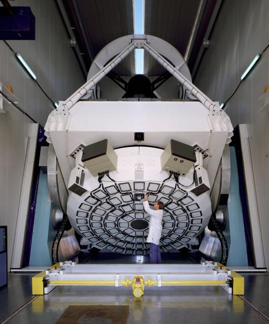
The New Technology Telescope (NTT) pioneered the active optics systems: its 3.56-meter diameter mirror is thin and flexible, and its shape is kept perfect thanks to the actuators supporting it.
Photograph by Claus Madsen, n.d.
Courtesy of ESO/C.Madsen.
Click here to view source.
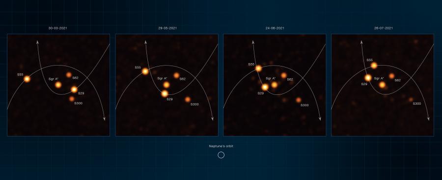
These annotated images, obtained with the GRAVITY instrument on ESO’s Very Large Telescope Interferometer (VLTI) between March and July 2021, show stars orbiting very close to Sagittarius A*, the supermassive black hole at the heart of the Milky Way. One of these stars, named S29, was observed as it was making its closest approach to the black hole at 13 billion kilometers, just 90 times the distance between the Sun and the Earth. Another star, named S300, was detected for the first time in the new VLTI observations.
To obtain the new images, the astronomers used a machine-learning technique called Information Field Theory. They made a model of how the real sources may look, simulated how GRAVITY would see them, and compared this simulation with GRAVITY observations. This allowed them to find and track stars around Sagittarius A* with unparalleled depth and accuracy.
2021.
Courtesy of ESO/GRAVITY collaboration.
Click here to view source.
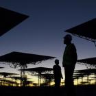
However, the great potential of the natural laboratory can still be further developed in what may become its area of greatest impact: the social factor. The science developed around a natural laboratory is associated with externalities, which involve the interaction, services, or development of other areas. These include astrotourism, sustainable energy generation, the transfer and analysis of big data, technological innovation, and education, among other things, which can generate poles of local development, involving and benefiting the communities that inhabit the territory where the natural laboratory is located.
The European Southern Observatory (ESO) arrived in Chile in 1963 due to the unique atmospheric conditions in the north of the country, which, with more than 90 percent of clear nights per year and low atmospheric turbulence, offers some of the best places for astronomical observation in the world. During its almost 60 years of existence ESO has managed to become one of the leading institutions in the construction and operation of telescopes and astronomical research worldwide. ESO has developed technologies that allow for more precise observations in optical and infrared telescopes, enabling cutting-edge research and discoveries with worldwide recognition, such as the 2019 and 2020 Nobel Prizes in Physics (2019: Michel Mayor and Didier Queloz for discovering an exoplanet orbiting a solar-type star; 2020: Reinhard Genzel and Andrea Ghez for discovering a supermassive compact object at the center of our galaxy). In addition, ESO is currently building the largest optical and infrared telescope on the planet, the Extremely Large Telescope (ELT) on Cerro Armazones in Chile. All the above would not be possible without the existence of the natural laboratory of the northern Chilean sky. But, largely, this is due to the construction of a strong and close relationship with the host country, which we continuously try to support, looking for new paths that bring benefits from astronomy to society.

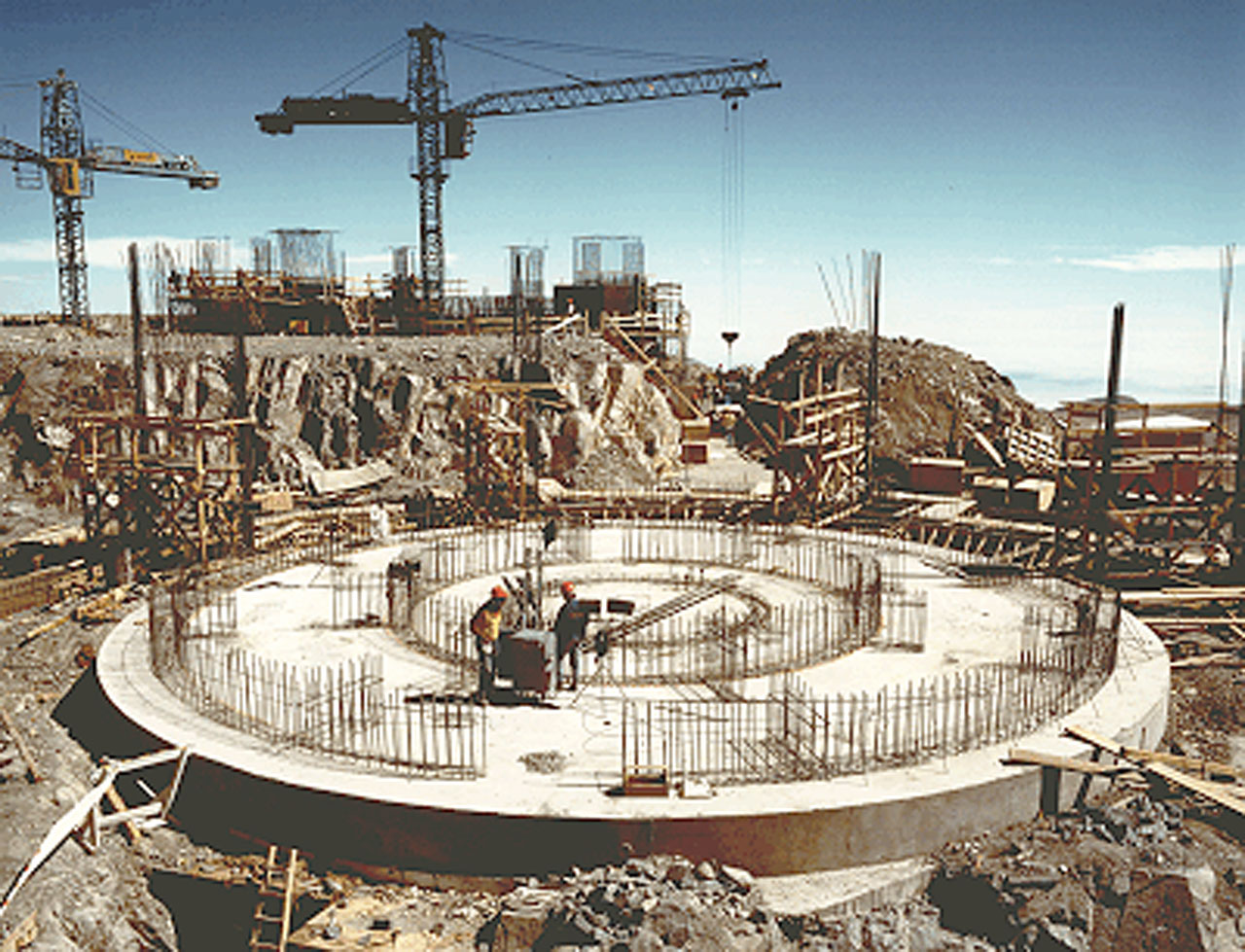
This photo was obtained in mid-September 1994 and shows the work at Cerro Paranal on the foundations for VLT Unit Telescopes no. 1 (background) and 2 (foreground). Unknown photographer, 1994.
This photo was obtained in mid-September 1994 and shows the work at Cerro Paranal on the foundations for VLT Unit Telescopes no. 1 (background) and 2 (foreground). Unknown photographer, 1994.
Courtesy of ESO.
Click here to view source.
This work is licensed under a Creative Commons Attribution 4.0 International License.

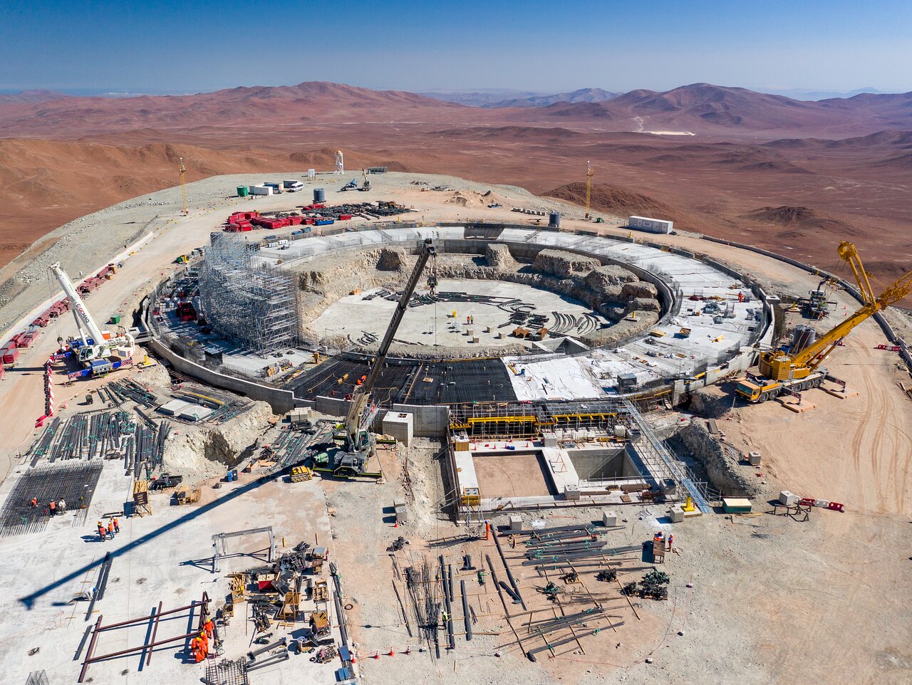
Construction of the world’s biggest eye on the sky, ESO’s Extremely Large Telescope (ELT), is making progress. After a significant slowdown of the building works due to the COVID-19 pandemic—including almost a year of complete site closure—works resumed in mid-2021. As this image from January 2022 shows, the foundations of the mammoth 39-meter telescope have been laid, taking us one step closer to uncovering some of the most elusive mysteries of the universe. Photograph by Gerhard Hüdepohl, 2022.
Construction of the world’s biggest eye on the sky, ESO’s Extremely Large Telescope (ELT), is making progress. After a significant slowdown of the building works due to the COVID-19 pandemic—including almost a year of complete site closure—works resumed in mid-2021. As this image from January 2022 shows, the foundations of the mammoth 39-meter telescope have been laid, taking us one step closer to uncovering some of the most elusive mysteries of the universe. Photograph by Gerhard Hüdepohl, 2022.
Courtesy of G. Hüdepohl (atacamaphoto.com)/ESO.
Click here to view source.
This work is licensed under a Creative Commons Attribution 4.0 International License.
Switch between the microcosm and macrocosm perspectives by clicking on the circles above.
From Hand Lenses to Telescopes: Exploring the Microcosm and Macrocosm in Chile’s Biocultural Laboratories
Chile is a land drawn with the rhythm of nature itself. It is a natural laboratory that invites us to look up into the macrocosm and down into the microcosm. At both extremes of this long and narrow country, science activities have a major global impact. Today, over 50 percent of the world’s astronomical observations use the telescopes of the European Southern Observatory (ESO) and other institutions installed in the Atacama Desert in northern Chile. Complementarily, at its southern end Chile established the Cape Horn International Center for Global Change Studies and Biocultural Conservation (CHIC) to investigate the microcosms, from the largest organism, planet Earth, to the smallest ones. CHIC explores diverse forms of knowledge and values to understand and protect the biosphere in the context of global socio-environmental change. This virtual exhibition enhances the integration of the sciences, arts, and humanities through a novel partnership with the Rachel Carson Center for Environment and Society, inviting visitors to be enchanted across the multiple scales of the cosmos.
About the ExhibitionAbout the author


