The Rivers and the Cities: A Brief Introduction
Both the Neva and the Viennese Danube are metropolitan rivers of two great empires. St. Petersburg and Vienna, as imperial capitals, were centers of politics, commerce, religion, and culture, and the flagship cities of empires. In each case, the role of the river—Pushkin’s “commanding, sovereign stream”—was decisive in the formation and development of urban space. However, the spatial relationships of the two cities with their rivers were quite different. St. Petersburg grew from the very beginning on both banks of the Neva and its many branches. The river was transformed into a major part of the city’s infrastructure and water supply, while its frozen surface became a central space of the city in winter. In contrast, medieval Vienna developed on the right bank at some distance from the main river, which nevertheless played a major role in transportation, fisheries, and other economic activities. In this section of the exhibition, we present and discuss how the rivers made two cities into flourishing and representative capitals, impressive for visitors and inspiring for the locals.
Switch between the Neva and Danube perspectives by clicking on the circles below.
The original virtual exhibition includes the option to switch between the cities St. Petersburg and Vienna within the individual chapters.
St. Petersburg and the Neva
The wet and marshy lands of the Neva river delta were poorly populated for centuries until the Russian Tsar Peter I gained control over this territory during the Great Northern War against Sweden and, on 27 May 1703, created a fortified port, which eventually became the Baltic metropolis and one of the greatest urban centers in the world. The development of the big city on the islands was very unusual for Russia and the new city appeared to be very European and modern in its structure, in comparison with Moscow and other Russian cities, and the importance of the Neva as a pillar of this space of modernity can hardly be overestimated.
The original virtual exhibition features an interactive gallery of images.
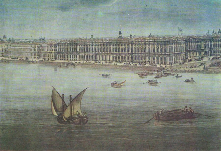
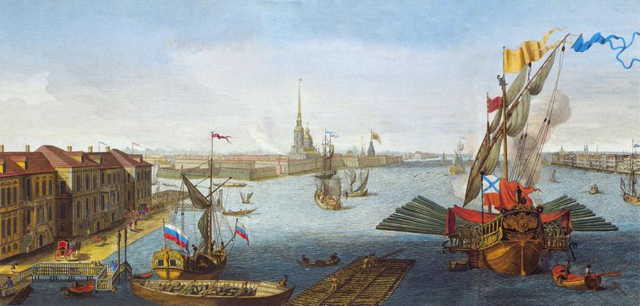
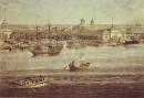
Panorama of St. Petersburg: Part 1 of 10
The Imperial Residence is clearly connected to the Neva. The pier can be seen in the drawing (right-hand side) as well as numerous boats, including quite luxurious ones.
Angelo Tozelli, Panorama of St. Petersburg, 1820. Part 1 of 10.
© The State Hermitage Museum. Used by permission.
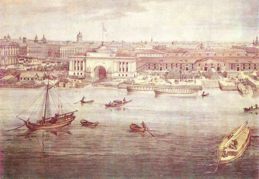
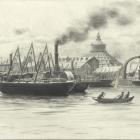
Panorama of St. Petersburg: Part 2 of 10
The Admiralty shipyard—the cradle of the Russian Navy. Everything here is delivered by water through the network of canals under the arches.
Angelo Tozelli, Panorama of St. Petersburg, 1820. Part 2 of 10.
© The State Hermitage Museum. Used by permission.
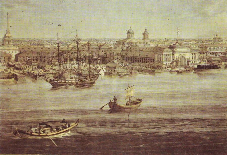
Panorama of St. Petersburg: Part 3 of 10
Open spaces (squares and yards) are connected to the Neva creating a remarkable feeling of vastness.
Angelo Tozelli, Panorama of St. Petersburg, 1820. Part 3 of 10.
© The State Hermitage Museum. Used by permission.

Panorama of St. Petersburg: Part 4 of 10
Floating bridges across the Neva appeared in 1727 and until the mid-nineteenth century no connection was possible between the banks during the ice flow. Only later would advanced permanent constructions change the situation.
Angelo Tozelli, Panorama of St. Petersburg, 1820. Part 4 of 10.
© The State Hermitage Museum. Used by permission.
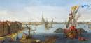
View of the Neva Downstream between the Winter Palace and the Academy of Sciences
The fortress provided military control of the Neva—obviously the most important strategic object of the city.
Efim Grigorievich Vinogradov and Mikhail Ivanovich Makhayev, View of the Neva Downstream between the Winter Palace and the Academy of Sciences, 1753. Etching with line engraving and watercolor, 51.2 x 136.84 cm.
© The State Hermitage Museum. Used by permission.
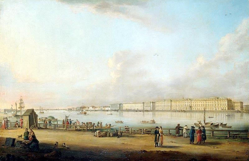
View of Winter Palace from Vasilievski island
The world-famous granite embankments of the Neva started as endless wooden piers. All the city transportation of both humans and commodities was based on the Neva. The Neva used to be, and still is, the favorite promenade for the representatives of all layers of the city’s population.
Johan Georg Mayr, View of Winter Palace from Vasilievski Island, 1796. Oil on canvas, 77 x 117 cm.
© The State Hermitage Museum. Used by permission.


St. Petersburg was formed on the islands of the southern part of the Neva delta, with its main center on the islands of Admiralteiskii, Kazanskii, Spasskii, and Vasilievskii, in the eighteenth and nineteenth centuries. Traditionally, the central districts, which were home to palaces, mansions, and public buildings, were situated on the banks of the Neva, and the river itself served as the city’s main public space both in summer and in winter.
The northern part of the delta became an important recreational area, with parks and summerhouses that belonged to wealthy and noble families. This was the territory of a pleasant but to a great extent “artificial” environment and the Neva there was an important part of a charming landscape. This man-made paradise existed until the late nineteenth and early twentieth centuries, when this area became the major zone of middle-class recreation.
As a result, the Neva, with its smaller rivers and canals, came to form something like the skeleton of the city’s urban structure. To some extent, we can say that the Neva in St. Petersburg is everywhere and almost any activity connected to the development of the city included some arrangements concerning the river, either as an obstacle to be overcome or as an opportunity to be exploited. As a result, the residents of the city have changed the river network as much as they adapted to it.
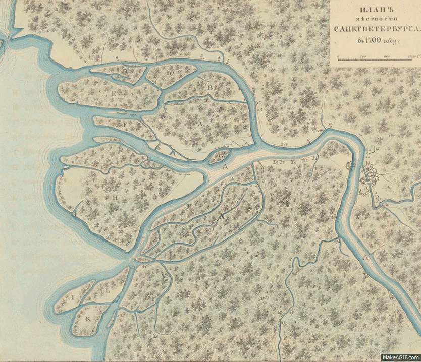
The original virtual exhibition features a dynamic GIF that visualizes the changing landscape of St. Petersburg and the Neva River between 1700 to 1849.

St. Petersburg in 1700, 1705, 1725, 1738, 1756, 1777, 1799, 1840, and 1849. Maps by Sostavleny N. Tsilovym.
St. Petersburg in 1700, 1705, 1725, 1738, 1756, 1777, 1799, 1840, and 1849. Maps by Sostavleny N. Tsilovym.
Maps by Sostavleny N. Tsilovym.
 This work is licensed under a Creative Commons Public Domain Mark 1.0 License.
In this part of the exhibition we tried to visualize the importance of the river in the general structure of the city, demonstrating the spatial links between the representative view of the northern capital of Russia and the picturesque bustle of city life on the one hand, and the majestic river on the other.
Vienna and the Danube

Vienna was founded in Roman times on the banks of the southernmost river arm of the Danube, today known as the “Donaukanal,” which translates as “Danube Canal.” The city was located on a Pleistocene terrace and was thus protected against floods. Because of the high fluvial dynamics, the riverine landscape remained—with one exception, the Unterer Werd—free of urban settlements until the mid-nineteenth century. Urban expansion was concentrated in the south and in the hilly west. An urban waterfront existed only on the right-hand banks of the Donaukanal. While for many centuries the Danube marked a clear boundary for the city’s development, it was at the same time the main transport route and a source of economic growth: most goods and commodities entering or leaving the city were traded on the river.
From the eighteenth to the twentieth centuries, the city and the river, as well as their relationship to each other, changed fundamentally. Until the river was channelized in the 1870s, aquatic and terrestrial areas were constantly shifting. The inhabitants of Vienna lived with their river, and the regular floods affected all the residents along the Donaukanal and in the Unterer Werd. The channelization stabilized the river and its floodplains. The latter were properly integrated into the city. A large part of today’s urban area is located on the former Danube floodplains and depends on the maintenance of a complex and costly flood protection system.
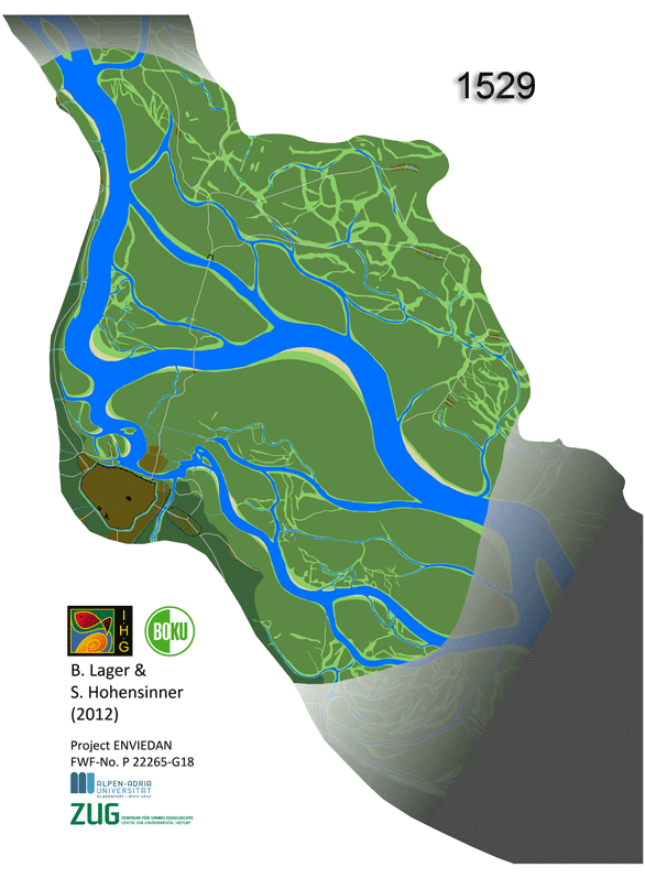
The original virtual exhibition features a dynamic GIF that visualized the transformation of the Viennese Danube river landscape between 1529 and 2010.

Transformation of the Viennese Danube river landscape between 1529 and 2010. The brown areas in the animation above highlight urban areas. Map by Bernhard Lager and Severin Hohensinner.
Transformation of the Viennese Danube river landscape between 1529 and 2010. The brown areas in the animation above highlight urban areas. Map by Bernhard Lager and Severin Hohensinner.
2012 Bernhard Lager and Severin Hohensinner (FWF Project-No. P 22265-G18)
 This work is licensed under a Creative Commons Attribution-NonCommercial-ShareAlike 3.0 Unported License.
Switch between the Neva and Danube perspectives by clicking on the circles above.
- Previous chapter
- Next chapter
“Commanding, Sovereign Stream”: The Neva and the Viennese Danube in the History of Imperial Metropolitan Centers
The exhibition aims to reveal and visualize the power of mighty rivers so crucially important for the history of St. Petersburg and Vienna—the major imperial centers of continental Europe in the modern era.
Gertrud Haidvogl, Alexei Kraikovski, and Julia LajusAbout the author


